The Storm Prediction Center has painted OHIO in a Moderate Risk for Severe Storms SUNDAY. To give you an historical reference point to what this means, OHIO usually goes under a MODERATE RISK only a few times a year. Bottom line, don't take this threat lightly.
GOOGLE+
https://plus.google.com/u/0/+ScottSabol/posts
TUMBRL
http://www.tumblr.com/blog/scottsabol
TWITTER
http://twitter.com/scottsabolfox8
Remember, a SEVERE THUNDERSTORM is a storm with 58 mph winds AND/OR 1" hail or a tornado. When any one of these criteria are met, a SEVERE THUNDERSTORM WARNING is issued.
Here are the meteorological parameters for tomorrow:
Super strong jet stream...left front exit region over Lake Erie
Upper level diverging air at 500mB (18,000 feet) which translates into rising air at the surface.
Pocket of HIGH surface winds across northern Indiana and Ohio exceeding 40-45 mph.
. Sharp temperature gradient...
Expect a fast moving squall line (embedded severe storms) late Sunday afternoon into the early evening Sunday. The timing a strength of the line of storms will need to be monitored.
Northeast Ohio weather and science blog covering severe storms, long term outlooks, climate, behavioral meteorology, technology and other observations
Saturday, November 16, 2013
Tuesday, November 12, 2013
Snowcover Photos from Across Northern Ohio
Now that the cold front has passed, the lake effect has begun with winds out of the NORTH Current RADAR LOOP shows localized lake effect as far west as Norwalk and as far south as Canton.
RADAR LOOP HERE
An atypical fetch for lake effect but one that we saw frequently back in the winter of 2009-2010. See my previous post on the DIFFERENT FLAVORS OF LAKE EFFECT SNOW.
Since the cloud are low level clouds with limited moisture, it doesn't take much wind to break up the clouds enough for some breaks of sunshine.
That partial sunshine made for some nice photos from FOX8 viewers earlier today.
 |
| Akron, Ohio snow |
 |
| Austinburg, Ohio |
 |
| Carrollton, Ohio |
 |
| Mayfield Heights |
 |
| Penfield, Ohio |
 |
| Rittman |
 |
| Canton |
 |
| Hudson |
Monday, November 11, 2013
Northern Ohio: First General Snowfall of the Season
We normally average about 5 inches or snow for the month of November. This Alberta Clipper coming in later this evening could bring that and more for parts of the snowbelt. Here's how this will shape up?
Temps will climb into the mid 40s with some strong winds later today.
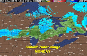
Rain will develop later in the afternoon. CLICK ON THE RADAR IMAGE BELOW FOR THE LATEST LOOP.
The high resolution model (HRRR) brings in the leading edge of the rain across northern Ohio by 3PM.
The transition from rain to wet snow will bring in the early evening and continue.
The initial snow from the front will give us about 1 to 3 inches of wet snow late evening and overnight. Then lake effect will develop primarily east and a bit south into northern Summit and Portage counties with a northwest wind.
The lake effect will give us an additional 1-3 inches tonight and Tuesday.
Temps will climb into the mid 40s with some strong winds later today.
 |
| TEMPS AND WINDS AS OF 8:45AM |
The high resolution model (HRRR) brings in the leading edge of the rain across northern Ohio by 3PM.
The transition from rain to wet snow will bring in the early evening and continue.
The initial snow from the front will give us about 1 to 3 inches of wet snow late evening and overnight. Then lake effect will develop primarily east and a bit south into northern Summit and Portage counties with a northwest wind.
The lake effect will give us an additional 1-3 inches tonight and Tuesday.


