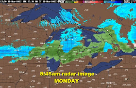
Temps will climb into the mid 40s with some strong winds later today.
 |
| TEMPS AND WINDS AS OF 8:45AM |
The high resolution model (HRRR) brings in the leading edge of the rain across northern Ohio by 3PM.
The transition from rain to wet snow will bring in the early evening and continue.
The initial snow from the front will give us about 1 to 3 inches of wet snow late evening and overnight. Then lake effect will develop primarily east and a bit south into northern Summit and Portage counties with a northwest wind.
The lake effect will give us an additional 1-3 inches tonight and Tuesday.


No comments:
Post a Comment
Note: Only a member of this blog may post a comment.