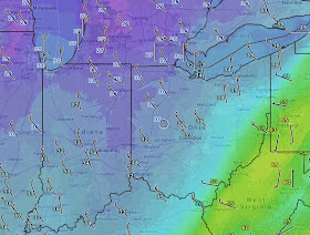
In anticipation of this huge swing last Friday, I dug up the occurrences of THIRTY DEGREE high temperature drops in TWO DAYS OR UNDER with at least one inch of snow in April. It was far from easy. After digging up the instances of snowfall, I had to cross reference the high temperature declines MANUALLY in each of those years. I say this not to complain--this kind of esoteric statistical research still needs to be done the old fashioned way--but to illustrate the work involved. So an hour of sifting through data results in only a few tidbits of blog trivia which fit nicely in two blocks below. For me its worth it, as I hope it is for you. Here are the results:
30 degree drop or more in 48 HOURS resulting in least 1" of snow: 5 TIMES
- 51 DEGREE DROP: 2007: 80 TO 29, 3" snow
- 38 DEGREE DROP: 1969: 82 TO 44, 1.5" snow
- 38 DEGREE DROP: 1921: 71 TO 33, 1.5" snow
- 32 DEGREE DROP: 1912: 64 to 32, 6.5" snow
- 30 DEGREE DROP: 1893: 71 to 41, 3.5" snow
- 36 DEGREE DROP: 1972: 67 TO 31, 1.7" of snow
- 33 DEGREE DROP: 1940: 60 TO 27, 3.2" of snow
- 31 DEGREE DROP: 1982: 63 TO 43, 1.7" of snow
- 30 DEGREE DROP: 1988: 63 TO 43, 2.3" of snow
This drop will go from 78 Sunday to upper 30s Tuesday (48 hours) just shy of the 51 degree drop listed above. The 24 hour drop starting this morning (73 degrees to upper 30s) will be close to the ALL-TIME record one day drop set back in 1972 listed above!
Lake Erie is wide open meaning that some lake enhancement will occur tomorrow as the cold air filters in from the northwest.
The ground is warmer than a few weeks ago so a lot of melting will occur as the rain changes over to wet snow. That said, slushy accumulations will occur:


No comments:
Post a Comment
Note: Only a member of this blog may post a comment.