We just finished one of the driest Septembers on record in northern Ohio.
Comparing August to September shows how the pattern flipped to a drier one starting in late August.
It wasn't just across Ohio, much of the Ohio Valley, mid-west and dep south (exception is east coast) saw below normal rainfall in September.
The comparisons are stark when comparing the
percentage of normal for the mid-west/Great Lakes versus August. Blue/green are regions above normal. Brown/tan/white colors are below normal.
What changed in late August/September?
Upper level pattern was stalled in August. Frequent fronts and rainfall.
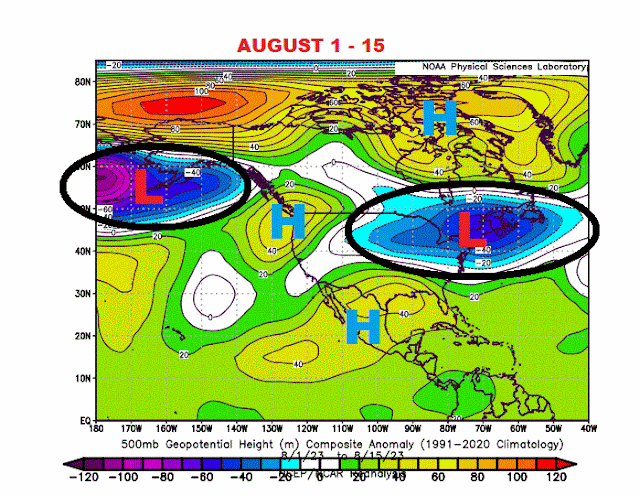 |
| AUGUST 1-15 |
Pattern started changing in late August. High pressure began to build across the upper mid-west and across western Canada.
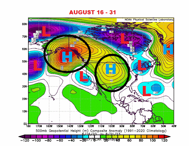 |
| AUGUST 16-31 |
By September, the pattern settled into this configuration. High pressure over Canada and across the SW US. Low pressure across the Gulf of Alaska and a weak low across the mid Atlantic (tropically driven)
You'd figure some of the moisture from the east coast/mid-Atlantic low would influence our weather across Ohio and the Great Lakes given the overall flow around the ridge over Canada. Yet the relative humidity, degree of rising air (Lifted Index) and the zonal winds were well below average.
Overall relative humidity:
Rising air (Lifted Index)
Zonal Winds
Jet stream across North America was especially strong from Indonesia east across the dateline into Mexico and the deep south. Northern branch was also very strong off of eastern Asia, across the Bering Sea and into the eastern Pacific. Very weak jet across the northern half of the US/Canada. This kept the strong low pressure outside the northern US/Great Lakes.
Dry conditions contributed to above normal temps in the upper mid-west with near normal temps across Ohio.
This is not a precursor of the winter ahead. More on a few of the drivers of winter 2023-24 in the weeks ahead.
.jpg)


.gif)


