Why is lake effect snow so localized? Moisture often times converges in pockets or streaks depending on the weather setup. Check out this great visible satellite photo which shows the streaks of clouds cover and sunny breaks in between. Each streak of cloud cover has bursts of lake effect embedded within it.
BTW, the 850 mB temperatures will be falling to -18 with a lake water temperature of +8 (yes, all in celsuis). You need around a 13 degree temperature difference. Notice that later today, tonight and early tomorrow, temperature differences approach 25! This means heavy bursts of snow IN LOCAL AREAS!
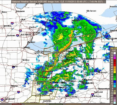
Saturday afternoon radar image...CURRENT NORTHERN OHIO RADAR LOOP HERE
Northeast Ohio weather and science blog covering severe storms, long term outlooks, climate, behavioral meteorology, technology and other observations
Saturday, November 23, 2013
Tuesday, November 19, 2013
How Rare Are "NOVEMBER SEVERE WEATHER HIGH RISK" Forecasts? VERY!
![]() |
| Damage from Washington, Illinois (Chicago Tribune) |
Only 2 other instances where the Storm Prediction Center issued forecasts for HIGH RISK FOR SEVERE WEATHER in November: 2002 and 1998. None of these HIGH RISKS were for any part of Ohio. Both of these featured large tornado outbreaks.
![]() |
| Image courtesy Greg Carbin, SPC |
![]() |
| Image courtesy: Eric Fisher/Jesse Ferrell on Twitter |
![]() |
| Image Courtesy Greg Carbin, SPC |
Aerial Photo of Tornado Path in Washington, Illinois
Notice the swirls along the path. This tornado was on the ground for 46.2 miles a an EF4 which had winds between 170-190 mph. This tornado had winds greater than any hurricane or Typhoon in recorded history!
Here are some other aerial photos courtesy of the Chicago Tribune.
Monday, November 18, 2013
Crying Wolf? I Think Not: Severe Weather Definitions
It never fails.
During and after each and every severe weather event, there are a few people that selfishly say "Where are the storms? You all said we'd have severe weather. All we're getting is wind and some rain. You weather people never get it right!" Nothing gets me more fired up more than idiotic comments like this. Tell this to the families who lost loved ones in this house in Nashville, Illinois.
My blood pressure is climbing just writing this......errrrrr!
I have written many times about how our perceptions and preconceived notions tend to govern our thoughts especially when events occur that seem to support and reinforce our biased notions. I try to tell these individuals that severe weather forecasts are approximations. That's why tornado watches are as large as a state not a city.
People will think the way they want to think regardless of how much data you present them to the contrary. How often have our biases surfaced during election years (economic issues), in our day-to-day lives perhaps when we interact with others? See my posts about cognitive biases and cognitive dissonance relating it to weather HERE and HERE. Note the parts in red print if you want the Cliffs Notes version.
Anyway, maybe these basic severe weather definitions will clarify some of these misconceptions and perceptions about severe weather. Bottom line is this: When the Storm Prediction Center has a region in a MODERATE to HIGH RISK for severe weather, bad things will happen. This is not something to be taken lightly.
During and after each and every severe weather event, there are a few people that selfishly say "Where are the storms? You all said we'd have severe weather. All we're getting is wind and some rain. You weather people never get it right!" Nothing gets me more fired up more than idiotic comments like this. Tell this to the families who lost loved ones in this house in Nashville, Illinois.
My blood pressure is climbing just writing this......errrrrr!
I have written many times about how our perceptions and preconceived notions tend to govern our thoughts especially when events occur that seem to support and reinforce our biased notions. I try to tell these individuals that severe weather forecasts are approximations. That's why tornado watches are as large as a state not a city.
People will think the way they want to think regardless of how much data you present them to the contrary. How often have our biases surfaced during election years (economic issues), in our day-to-day lives perhaps when we interact with others? See my posts about cognitive biases and cognitive dissonance relating it to weather HERE and HERE. Note the parts in red print if you want the Cliffs Notes version.
Anyway, maybe these basic severe weather definitions will clarify some of these misconceptions and perceptions about severe weather. Bottom line is this: When the Storm Prediction Center has a region in a MODERATE to HIGH RISK for severe weather, bad things will happen. This is not something to be taken lightly.
Labels:
public awareness,
severe weather,
thunderstorms,
tornadoes
Sunday, November 17, 2013
OHIO SEVERE WEATHER UPDATE: 8PM
TORNADO WATCH still in effect for all of northern Ohio until 12AM. This means CONDITIONS are still FAVORABLE. No confirmations of any touchdowns in northern Ohio. Watch might be cancelled before 12AM. Stay tuned...
CHECK OUT MY TWITTER FEED FOR ANY WARNINGS ISSUED
Earlier today, updates here projected the main line of storms to be approaching western areas of Ohio by 6PM. Here was this initial map created by the HRRR model.
Here is the radar image at 8PM...line is moving a bit faster CLICK ON THE RADAR IMAGE FOR THE CURRENT RADAR LOOP OVER OHIO
Between 8 and 10PM, expect fast moving (50-60 mph) storms across northern Ohio. Some will be severe
By 10PM, the majority of the storms should be out the area...
Notice the temperature drop behind the front circled in BLUE.
We'll wake up to temps in the lower to mid 40s Monday morning.
SEVERE WEATHER UPDATE: Sunday NOON UPDATE
Everything is still pointing to a HIGH POTENTIAL for severe thunderstorms THIS AFTERNOON AND THIS EVENING.
Remember, a SEVERE STORM is a storm with 58 mph winds AND/OR 1" hail or a tornado. When any one of these criteria are met, a SEVERE THUNDERSTORM WARNING is issued. A TORNADO OR SEVERE THUNDERSTORM WATCH means conditions are favorable. WARNING means its occurring now!
RADAR SNAPSHOT AT OF 11:30AM
CLICK HERE TO SEE THE MOST RECENT RADAR LOOP
Plenty of sunny breaks which will only destabilize the atmosphere which will promote more storm development. Visible satellite image here...
The discussion posted here yesterday still holds:
High resolution HRRR model brings the main line of strong/severe storms into western Ohio by 6PM...8PM across northern Ohio
Storm Prediction Center has shifted the MODERATE and HIGH RISK area further east. HIGH RISK now in western Ohio!!!
To put this into perspective, Ohio is put into a HIGH risk SEVERE WEATHER area about once every 3-5 years.
Upper level diverging air at 500mB (18,000 feet) which translates into rising air at the surface.
A very large temperature gradient. Sunday morning temperatures are already pushing 60 across northern Ohio
All of these conditions will produce very strong winds at the surface in excess of 40-45 mph later today.
TORNADO WATCH ISSUED FOR NORTHERN INDIANA, FAR WESTERN OHIO UNTIL 8PM
RADAR SNAPSHOT AT OF 11:30AM
CLICK HERE TO SEE THE MOST RECENT RADAR LOOP
Plenty of sunny breaks which will only destabilize the atmosphere which will promote more storm development. Visible satellite image here...
The discussion posted here yesterday still holds:
High resolution HRRR model brings the main line of strong/severe storms into western Ohio by 6PM...8PM across northern Ohio
Storm Prediction Center has shifted the MODERATE and HIGH RISK area further east. HIGH RISK now in western Ohio!!!
To put this into perspective, Ohio is put into a HIGH risk SEVERE WEATHER area about once every 3-5 years.
Tornado chances seem higher in Illinois and Indiana
Super strong jet stream...left front exit region over Lake ErieUpper level diverging air at 500mB (18,000 feet) which translates into rising air at the surface.
A very large temperature gradient. Sunday morning temperatures are already pushing 60 across northern Ohio
All of these conditions will produce very strong winds at the surface in excess of 40-45 mph later today.
Saturday, November 16, 2013
Severe Storms VERY Possible Across OHIO SUNDAY AFTERNOON
The Storm Prediction Center has painted OHIO in a Moderate Risk for Severe Storms SUNDAY. To give you an historical reference point to what this means, OHIO usually goes under a MODERATE RISK only a few times a year. Bottom line, don't take this threat lightly.
GOOGLE+
https://plus.google.com/u/0/+ScottSabol/posts
TUMBRL
http://www.tumblr.com/blog/scottsabol
TWITTER
http://twitter.com/scottsabolfox8
Remember, a SEVERE THUNDERSTORM is a storm with 58 mph winds AND/OR 1" hail or a tornado. When any one of these criteria are met, a SEVERE THUNDERSTORM WARNING is issued.
Here are the meteorological parameters for tomorrow:
Super strong jet stream...left front exit region over Lake Erie
Upper level diverging air at 500mB (18,000 feet) which translates into rising air at the surface.
Pocket of HIGH surface winds across northern Indiana and Ohio exceeding 40-45 mph.
. Sharp temperature gradient...
Expect a fast moving squall line (embedded severe storms) late Sunday afternoon into the early evening Sunday. The timing a strength of the line of storms will need to be monitored.
GOOGLE+
https://plus.google.com/u/0/+ScottSabol/posts
TUMBRL
http://www.tumblr.com/blog/scottsabol
http://twitter.com/scottsabolfox8
Remember, a SEVERE THUNDERSTORM is a storm with 58 mph winds AND/OR 1" hail or a tornado. When any one of these criteria are met, a SEVERE THUNDERSTORM WARNING is issued.
Here are the meteorological parameters for tomorrow:
Super strong jet stream...left front exit region over Lake Erie
Upper level diverging air at 500mB (18,000 feet) which translates into rising air at the surface.
Pocket of HIGH surface winds across northern Indiana and Ohio exceeding 40-45 mph.
. Sharp temperature gradient...
Expect a fast moving squall line (embedded severe storms) late Sunday afternoon into the early evening Sunday. The timing a strength of the line of storms will need to be monitored.
Tuesday, November 12, 2013
Snowcover Photos from Across Northern Ohio
Now that the cold front has passed, the lake effect has begun with winds out of the NORTH Current RADAR LOOP shows localized lake effect as far west as Norwalk and as far south as Canton.
RADAR LOOP HERE
An atypical fetch for lake effect but one that we saw frequently back in the winter of 2009-2010. See my previous post on the DIFFERENT FLAVORS OF LAKE EFFECT SNOW.
Since the cloud are low level clouds with limited moisture, it doesn't take much wind to break up the clouds enough for some breaks of sunshine.
That partial sunshine made for some nice photos from FOX8 viewers earlier today.
RADAR LOOP HERE
An atypical fetch for lake effect but one that we saw frequently back in the winter of 2009-2010. See my previous post on the DIFFERENT FLAVORS OF LAKE EFFECT SNOW.
Since the cloud are low level clouds with limited moisture, it doesn't take much wind to break up the clouds enough for some breaks of sunshine.
That partial sunshine made for some nice photos from FOX8 viewers earlier today.
![]() |
| Akron, Ohio snow |
![]() |
| Austinburg, Ohio |
![]() |
| Carrollton, Ohio |
![]() |
| Mayfield Heights |
![]() |
| Penfield, Ohio |
![]() |
| Rittman |
![]() |
| Canton |
![]() |
| Hudson |
Monday, November 11, 2013
Northern Ohio: First General Snowfall of the Season
We normally average about 5 inches or snow for the month of November. This Alberta Clipper coming in later this evening could bring that and more for parts of the snowbelt. Here's how this will shape up?
Temps will climb into the mid 40s with some strong winds later today.
Rain will develop later in the afternoon. CLICK ON THE RADAR IMAGE BELOW FOR THE LATEST LOOP.
The high resolution model (HRRR) brings in the leading edge of the rain across northern Ohio by 3PM.
The transition from rain to wet snow will bring in the early evening and continue.
The initial snow from the front will give us about 1 to 3 inches of wet snow late evening and overnight. Then lake effect will develop primarily east and a bit south into northern Summit and Portage counties with a northwest wind.
The lake effect will give us an additional 1-3 inches tonight and Tuesday.
Temps will climb into the mid 40s with some strong winds later today.
![]() |
| TEMPS AND WINDS AS OF 8:45AM |
The high resolution model (HRRR) brings in the leading edge of the rain across northern Ohio by 3PM.
The transition from rain to wet snow will bring in the early evening and continue.
The initial snow from the front will give us about 1 to 3 inches of wet snow late evening and overnight. Then lake effect will develop primarily east and a bit south into northern Summit and Portage counties with a northwest wind.
The lake effect will give us an additional 1-3 inches tonight and Tuesday.
Friday, November 08, 2013
Super Typhoon Haiyan - One For The Record Books
Super Typhoon Haiyan made landfall over the Philippines Thursday afternoon Eastern Standard Time with winds reported at 195 mph. Keep in mind that in the western Pacific, unlike the Atlantic where Hurricane Hunters fly into hurricanes to take wind and pressure measurements, no flights are made into these tropical systems. So wind speeds are estimated with satellite data. Some verification of the 195 mph speed will need to be done before the experts can say with certainty that this is legit.
A great visible satellite image and loop showing the well defined eye as it passed
Now the loop. Click on the image below
Watch the feeder bands weaken through this microwave imagery satellite loop as it passes over land then reorganize once over open water
A really neat image from Eurosat with the curvature of the earth as a reference point. The diameter of Typhoon Haiyan is roughly 400 miles. Hurricane Katrina's diameter was similar.
What are the tropical storms that had wind speeds of 190 mph?
Typhoon Tip in 1979 hit 190 mph at peak intensity in the western Pacific
Hurricane Camille in 1969 had wind speeds of 190 mph when it hit the Gulf Coast
For comparison sake, Hurricane Katrina had wind speeds of 120mp when it hit Louisiana in 2005
According to Dr Jeff Masters of the Weather Underground, typhoon wind speed estimates were too high in the 1940s through the 1960s. He has a list of typhoon wind speeds from that period that are a bit suspect HERE.
The track of Typhoon Haiyan is west over the South China Sea and into Vietnam Sunday.
A great visible satellite image and loop showing the well defined eye as it passed
Now the loop. Click on the image below
Watch the feeder bands weaken through this microwave imagery satellite loop as it passes over land then reorganize once over open water
A really neat image from Eurosat with the curvature of the earth as a reference point. The diameter of Typhoon Haiyan is roughly 400 miles. Hurricane Katrina's diameter was similar.
What are the tropical storms that had wind speeds of 190 mph?
Typhoon Tip in 1979 hit 190 mph at peak intensity in the western Pacific
Hurricane Camille in 1969 had wind speeds of 190 mph when it hit the Gulf Coast
For comparison sake, Hurricane Katrina had wind speeds of 120mp when it hit Louisiana in 2005
According to Dr Jeff Masters of the Weather Underground, typhoon wind speed estimates were too high in the 1940s through the 1960s. He has a list of typhoon wind speeds from that period that are a bit suspect HERE.
The track of Typhoon Haiyan is west over the South China Sea and into Vietnam Sunday.
Subscribe to:
Posts (Atom)