Showing posts with label storms. Show all posts

Wednesday, June 22, 2016

Severe Event Likely Tonight. How Do I Convey The Message?

A significant severe weather event is likely across the Ohio Valley tonight. The Storm Prediction Center has western Ohio under a moderate risk, a slight risk for the center of northern Ohio overnight. We are only under a moderate risk a few times a year.  So far, no tornado warnings have been issued for any county in northern Ohio, a rarity this late into June. This is a situation that we need to take seriously.


Radar shows the first of two storm clusters passing just south of northern Ohio. Notice the movement: Northwest to Southeast on the eastern edge of the central US ridge.


At a speaking engagement recently, I surveyed the group of around a hundred people what word they think of when I say the words severe when referring to the weather. The majority of them said tornado. Yet statistically, roughly 10% of severe storms produce a tornado. This is why you will rarely hear me use the word severe unless the situation absolutely warrants it. The word severe is very powerful and conjures up powerful imagery and perceptions. Weather situations like the one tonight (June 23, 2016) reminds me of the psychology behind our weather forecasts.

I'd like to say that I make a forecast with a cold, rational eye but I don't. I take into account how people with react to EACH WORD knowing that most people will react with their preconceived weather notions they've developed over time. Viewers hear the word severe and they think tornado. They panic and fear the worse even if the cold hard facts say otherwise. Its hard to reverse that mindset. I learned that real quick after my first major lake effect event twenty years ago.

If I could make a poster with bullet points for meteorologists, it would list these five at the top

*  Public perception is very powerful

*  We need to be better communicators of information. Quality of the information is better than clicks or social media engagement

*  Choice of words is of the utmost importance in conveying severity of any weather situation

*  For the public, risk is personal and evokes powerful imagery.  Mass media is for the masses.  Yet the masses in this era of smartphone weather apps want personal forecasts. Huge conundrum.

*  Too much emphasis on uncertainty breeds confusion and inaction. (I am hugely guilty of this as a technical weather geek) We need to find a delicate balance between voicing uncertainty and sticking to a forecast without blowing the event out of proportion.

Thursday, April 09, 2015

Heavy Rain and Storms Today

Our first real taste of widespread rain and storms since late last year. Rainfall amounts could exceed an inch over the next 24 hours where heavier downpours develop.


Current LIGHTNING STRIKES HERE


Severe storms are possible. The Storm Prediction Center has places northern Ohio in a SLIGHT RISK with the biggest threat coming from HIGH WINDS.


Remember, the SPC has changed their severe risk categories. Here is a chart comparing the old to the new.

A severe storm does not mean that storm will include tornadoes as many believe. In fact, less than 10 PERCENT or severe storms produce tornadoes.

Current Ohio Valley radar loop

Central Great Lakes sector loop

Thursday, October 02, 2014

Huge Changes - CURRENT RADAR LOOPS and OHIO TEMPERATURES

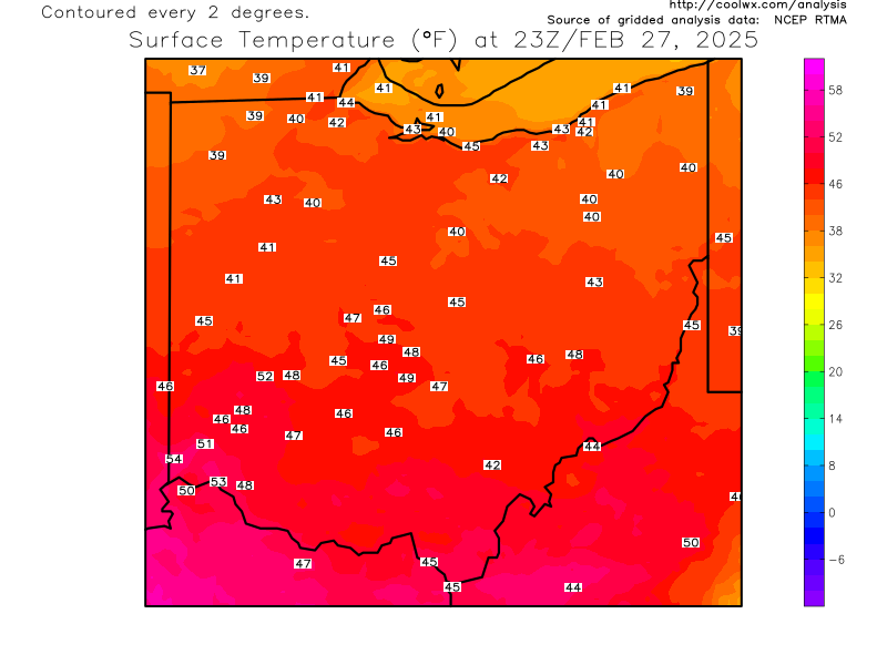
CURRENT RADAR LOOPS AND CURRENT OHIO TEMPERATURE, TEMPERATURE FORECAST THROUGH SATURDAY MORNING


Current OHIO temperatures


Current Ohio Valley radar loop
Central Great Lakes sector loop

Temperature forecast for this afternoon...70s...dropping into the 50s...40s by early morning.


Wednesday, October 01, 2014

HUGE changes Friday & Saturday

Welcome to October.

The deeper we go into October, the possibility of more drastic the day-to-day weather changes increases. The next few days are a prime example.

Central Great Lakes sector loop

High temperatures Friday could push into the 70s before the cold front move through.

Friday's Temperatures
Widespread rain and storms Friday afternoon with scattered storms Friday evening for high school football.

Wind gusts could reach 40+ mph along the front late Friday state wide.

 ...then the big drop Saturday across the midwest and Great Lakes.

Saturday's Temperatures
Look how the flood gates open up as the jet stream buckles across the lakes keeping temps in the 50s through early next week.

It won't be long now before I will need to reference my LAKE EFFECT SNOW EVENTS book!


Tuesday, June 24, 2014

Heavy Rain Update: Flash Flood Potential VERY HIGH

The ground is saturated from Monday's rain. An additional 1-3" of rain a very good possibility over the next 18 hours. Flash Flooding is the greatest concern. FLASH FLOOD WATCH FOR ALL OF NORTHERN OHIO UNTIL 10PM THIS EVENING. THIS MIGHT BE EXTENDED.

CURRENT RADAR LOOPS AND CURRENT OHIO TEMPERATURES


OHIO TEMPERATURES


OHIO VALLEY RADAR LOOP

Central Great Lakes sector loop

.


Why The Surprise Tornado In Brunswick, Ohio?

Yesterday (Monday 6-24-2014), a tornado touched down just south of RT. 303 in Brunswick without a tornado warning. (Note: A severe thunderstorm warning was issued by the NWS). What caused this tornado to develop? Was this tornado something that could have been foreseen? What happened?

Check out the radar loop I uploaded from yesterday (Monday evening).


Notice two elements: 1) The line or boundary just south of Lake Erie and 2) The other boundary that moved north of Wooster. These boundaries are called "outflow boundaries" or a "Gust Front". Put simply, these boundaries are like waves that propagate away from a boat that passes In this case, The boundary marks an area of sinking, cooler air that moves away from the first line of storms northeast of Cleveland. Some look like this:


As the boundary moved south away from Lake Erie (and north from near Wooster) it acted as a super-small scale cold front lifting the warm/moist air ahead of it enhancing the storm cluster already moving in from the west causing rotation and ultimately a tornado with winds of at least 110 mph. The convergence of these two boundaries and the established storm from the west (which already had minimal rotation according to the Cleveland NWS) provided the necessary ingredients for a rapidly developing tornado. All of this occurred within 10-15 minutes. Something like this is nearly impossible to forecast.

Friday, June 13, 2014

Awesome Power of Lightning

This video was taken from a security camera from outside the Saratoga Spring Performing Arts Center at the Saratoga Spa State Park in New York back on June 3rd. Notice the tree at the top of the screen below the "4" in "2014".

This is what 50,000+ degrees and a million volts of electricity can do in a fraction of a second.


Thursday, May 22, 2014

Vivid Lightning Photos

A cluster of storms developed over the western basin of Lake Erie around 6PM Wednesday evening. It continue to slide southeast through Lorain, Cuyahoga, Medina and Summit counties. Viewers captured these cloud to cloud lightning strikes.


Tuesday, May 20, 2014

Never Trust A Warm Front--Heavy Rain Again!

"Never Trust A Warm Front"!

These words of Dick Goddard and Andre Bernier have also been echoed by myself over the years after forecasting many heavy rain and nighttime severe weather events in northern Ohio, West Virginia and St. Louis going back more than 20 years.

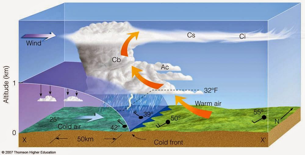
Why are warm fronts so tricky? The dynamics of a warm front are completely different than a cold front. The cross section of each tell the story on how the air is stacked above each front. A more detailed technical discussion is located on this site with a nice powerpoint download.

Cold Front Cross Section
Warm Front Cross Section
Clusters of "blob-like" storms tend to develop along warm fronts. These clusters start vie for position and dominance as they move into areas more conducive for sustainability. One cluster robs another of energy/moisture in order to sustain itself while other might shrink.  Yet several clusters might merge together to form one super cluster as was the case on Monday, May 12th. Radar loop is over approx 40 minutes from 8PM to 8:40PM over northern Ohio.


The combination of a moisture-laden atmosphere, rapidly rising and divergent (separating air) at the top of the storms along with hyper-local changes as the storms evolve over a small area make these clusters very difficult to predict more than a few hours in advance in many instances. Their non-linear nature makes it very difficult to determine an accurate track and duration.  They can become especially powerful during the overnight/predawn hours. The high resolution NAM below (future radar) shows several clusters overnight Tuesday into Wednesday more than 24 hours in advance. Their movement is usually west to east or northwest to southeast along the warm frontal boundary.


Compare that to what a "typical" line of storms looks like along a powerful cold front.


So watch the radar below tonight and early Wednesday for the "cluster-type" setup. These clusters can accelerate and morph into hail producing, high wind storms easily reach severe limits.

I GUARANTEE THAT SOME LOCATIONS WILL RECEIVE MORE THAN 1" OF RAINFALL ON WEDNESDAY!


Central Great Lakes sector loop