Saturday, December 21, 2013

Heavy Rain Continues; River Flood Forecasts for Northern Ohio


SEVERE THUNDERSTORM WATCH FOR SOUTHERN OHIO UNTIL 3AM


Current radar loop shows widespread rainfall across not only Ohio but across the Ohio Valley. A line of storms will push though southern Ohio. Some storms are possible across portions of northern Ohio. LOOP AT THIS LINK


Rainfall amounts will be between 2 and 3 inches in many locations.
The initial flooding was due to snow melt which amounted to between 1/2" and an 1"+ of liquid. Now with a good 2" of rain today and tonight rivers will rise rapidly. Here are some river forecasts for northern Ohio. Most river will peak late Sunday and Sunday night.

HURON RIVER AT MILAN
KILLBUCK CREEK
BLACK RIVER AT ELYRIA
GRAND RIVER AT PAINESVILLE
CHAGRIN RIVER AT WILLOUGHBY
CHAGRIN RIVER
CUYAHOGA RIVER AT INDEPENDENCE
TUSCARAWAS RIVER IN MASSILLON
CUYAHOGA RIVER IN AKRON


Wednesday, December 18, 2013

Heavy Rain & Flash Flood Forecast

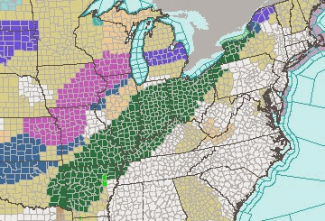
FLOOD WATCH FOR PORTIONS OF 10 STATES
FLOOD WATCH GOES INTO EFFECT FOR MOST OF OHIO FROM SATURDAY MORNING UNTIL SUNDAY EVENING...

Temps will slowly rise into the 40s with a possible 50+ by Sunday. The boundary between the milder air and the winter cold push next week will be very close to northern Ohio.

A stalled front will set up shop along the sharp temperature boundary. Rainfall will be heavy and extensive across the midwest and Ohio.
 
 Initial projections give northern Ohio over 2" by Sunday afternoon.
What about flooding? The snow cover is anywhere from 3 inches south up to a foot in the snowbelt. The liquid equivalent of the snow is around an inch to locally higher amounts.

6 hour Flash Flood guidance for Ohio shows we would need at least 2 inches of rain over a 6 hour time to create flash flood conditions. This does not take into account the snow melt however.

Combining the snow melt and the heavy rainfall, the National Weather Service has included much of Ohio in a "Potential Flash Flood" area for late Sunday. 

Here are some river water stage forecasts for the next 10 days. All rivers below except the Tuscarawas River near Massillon show minor flooding late Sunday into Monday. For current forecasts, here is the site RIVER FORECASTS

Cuyahoga River at Independence - Peak early Monday 12/23

Grand River at Painseville - Peak Sunday night 12/22
Huron River at Milan - Peak Sunday morning 12/22

Tuscarawas River at Massillon - Peak late Sunday through Tuesday

Monday, December 16, 2013

Does Our Snowy Start Mean A Snowy Winter Overall?


Marblehead Lighthouse

The collective belief that this winter will be super-cold and snowy is loud after the recent snow and long period of colder than normal temperatures.  While the drivers of winter are pointing to this season (December through February) being colder and snowier than average, a cold and snowy start (late November and early December) doesn't always carry over.

Look at the snowfall totals by December 15th since the early 1950s. 2013 is on the far right with 15 inches so far. Most winters we have well below 15 inches by December 15th going back to the early 1950s. I highlighted the snowiest winter (2004-05) and the winter of 1977-78 which was made memorable because of two historical blzzards in January.


 Here is the list in order from top to bottom. Surprisingly, 2013 is 14th on the list since 1954


How much snow did we end up with at the end of the winter in the years which had the same or more snow on December 15th?

8 of the 13 winters had final snow totals BELOW THE AVERAGE of 68 inches!


This is a purely statistical comparison as the dynamic drivers of many of these winters are totally different than the current drivers and conditions. What does all of this show?  It illustrates that we shouldn't be fooled or convinced that this winter will be snowier based on what has happened so far.

Anything can happen.