After the snow early this week, its understandable if people start to question our snowfall predictions. I heard it from friends and family alike: "What happened to that 1-3 inches you talked about this morning?" I can feel it even now. A blanket of "forecasting cynicism" hangs over the area like a thick layer of fog.
Honestly, I understand why everyone reacted this way. The snow hit right before rush hour. Viewers were mad. Kids were mad. Everyone was mad, testy and probably hungry after a 3 hour ordeal in the car, stalled in traffic with no end in sight. If I wasn't working, I probably would have had a few choice words too.
But not to worry. Another major winter storm is heading this way. In an effort to be vindicated from my latest forecasting mishap, (my dad called it a debacle"), I am here to present ALL POSSIBLE FORECASTS relating to this upcoming blast of late season winter slop.
Three different computer simulations are cranking three different snowfall projections. The last map is our consensus. Hopefully it works out...
Excuse my sarcasm...:)
Northeast Ohio weather and science blog covering severe storms, long term outlooks, climate, behavioral meteorology, technology and other observations
Thursday, February 24, 2011
Thursday, February 10, 2011
A Look at THIS WINTER in CLEVELAND so far...
Normally when I am greeting by someone when I'm out and about, they, more often than not, express their opinions about the morning show. Recently, a common salutation of "hi...watch you every morning" has been replaced with: "This has to be the coldest winter in AGES!"
So I went back to work, checked the temperature and snowfall numbers and here is what I found:
First, out seasonal snow through February 10th. Notice that this year, the totals are not all that high compared to the normal (average over the last 30 years)
The average temperatures didn't even make the TOP 10 coldest.
While the average temperatures were not close to record setting, we did have consistantly COLD temperatures BELOW FREEZING. Here are the number of days below freezing compared to the last 5 winters through February 10th. TWICE AS MANY days below freezing this winter compared to last winter
What about days with SNOW ON THE GROUND? This year is very close to last winter with SNOW ON GROUND days. Overall, the numbers are inching up each year over the last 4 winters.
The amount of snow or the overall temperatures haven't been the story as much as the CONSISTENT BELOW FREEZING TEMPERATURES.
So I went back to work, checked the temperature and snowfall numbers and here is what I found:
First, out seasonal snow through February 10th. Notice that this year, the totals are not all that high compared to the normal (average over the last 30 years)
The average temperatures didn't even make the TOP 10 coldest.
| Thanks goes to the NWS in Cleveland |
While the average temperatures were not close to record setting, we did have consistantly COLD temperatures BELOW FREEZING. Here are the number of days below freezing compared to the last 5 winters through February 10th. TWICE AS MANY days below freezing this winter compared to last winter
What about days with SNOW ON THE GROUND? This year is very close to last winter with SNOW ON GROUND days. Overall, the numbers are inching up each year over the last 4 winters.
The amount of snow or the overall temperatures haven't been the story as much as the CONSISTENT BELOW FREEZING TEMPERATURES.
Friday, February 04, 2011
A Look at JANUARY TEMP ANOMOLIES - CLEVELAND/USA/GLOBAL
Monday, January 31, 2011
Major Midwest Snowstorm Developing
...This storm will occur in two waves. The first is wet snow Monday night into Tuesday. Here are the initial snow amounts.
30 states under some sort of WINTER WEATHER WATCH OR WARNING
The FIRST WAVE of winter weather develops overnight tonight. WET SNOW into TUESDAY
The SECOND WAVE develops TUESDAY NIGHT into WEDNESDAY AM. Winds Wednesday morning could exceed 30-40 mph
Wednesday, January 26, 2011
Tuesday, January 25, 2011
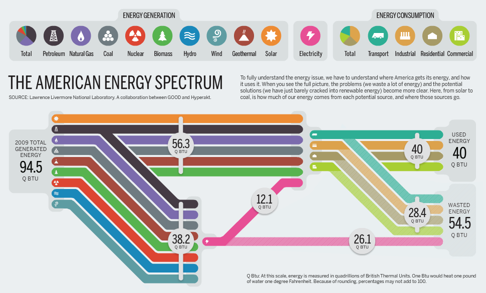
America's Energy Spectrum/Usage
A great interactive graph on American Energy Comsumption. Click here for the interactive picture
![]() |
| The American Energy Spectrum: Courtesy: http://www.good.is |
Friday, January 21, 2011
Arctic Air is HERE!
We knew it was a matter of time before temperatures sank into the single digits across Cleveland and northern Ohio. If you think our cold air harsh, check out the morning temperatures across northern Minnesota.
The arctic air settled in over Canada just after the first of the year. Over the last 3 weeks, its southerly progression was slow.
In fact, International Falls dropped from -9 to -41 in just under 7 hours. Here is a list of the current conditions from Thursday evening and Friday morning.
The arctic air settled in over Canada just after the first of the year. Over the last 3 weeks, its southerly progression was slow.
![]() |
| Temps on New Years Day |
![]() |
| Temps on January 18th |
Thursday, January 20, 2011
University of Akron - Winterfest 2011 Photos
I had the privilege of going live from the Winterfest at the University of Akron Wednesday morning. These students and former students are some of the most talented individuals in the area. Below are pictures from the event.
Friday, January 14, 2011
Random Charts and Graphs
Subscribe to:
Posts (Atom)