Showing posts with label tornado. Show all posts

Monday, December 16, 2024

First San Francisco Tornado Warning Ever!

Tornadoes in California are a rarity but not unprecedented. 


 Here is the short list of tornado warnings issued by the NWS office in San Francisco since 1989:


Composite map showing all 9 tornado warnings since 1986.


Each tornado warning and the radar composite for each event:
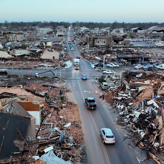
December 14, 2024

The warning went out before 6am Saturday and ended at 6:15am. Damage assessments from the NWS said the tornado had peak winds of 90 mph


A team from the National Weather Service San Francisco Bay Area conducted a storm survey in Scotts Valley. The team identified a swath of tornadic damage that began near the intersection of Mount Hermon Rd and Lockewood Ln and continued southeast along Mount Hermon Rd until just short of Kings Village Rd. A wide range of damage was observed including: downed trees, downed power poles, trees stripped of branches, numerous overturned vehicles, and damaged street signs. Based on these damage indicators the survey team assessed a maximum wind speed of 90 mph, which is a weak EF1 tornado.


March 2, 2024


March 18, 2011


January 20, 2010


January 23, 2010


September 18, 1989


Thursday, February 29, 2024

Tornado Warnings to Snowfall: How Often?


February 28 featured temperatures in the lower and mid 60s with thunderstorms. A handful of thunderstorm warnings with ONE tornado warning in Knox County around 6am February 28.  This tied the earliest tornado warning of the season (2011 was the other year)


Severe weather across multiple states.


Temperatures dropped quickly from mid 60s to the 20s by early evening across northern Ohio. Scattered snow showers develop in the evening with a heavy band of lake effect by February 29 between 5 and 8am.


The drop in temperature impacted the entire Mid-west, Ohio Valley and Great Lakes.  Here is an animation showing the temperatures from 2:45pm Tuesday 2/27 through 2:45am Wednesday 2/29:


Radar loop for the northern Ohio shoreline the following morning (Thursday AM) shows a significant band of lake effect snow:


How often do we go from TORNADO WARNINGS to SNOW in 24 hours? Here is the short list:


How about TORNADO WARNINGS to SNOW in 48+ hours?


So its been 7 years -- March 3, 2017 -- since we had measurable snow 24 hours after a tornado warning!


Tuesday, December 14, 2021

Deadly December Tornado Outbreak Recap

The clean up continues across the south after Saturday's deadly tornado outbreak.


people lost their lives as 71 tornadoes hit after dark between  December 10 and 11 across parts of 4 states. This LINK HERE lists multiple resources on the damage assessments.


More than 48 hours prior to the event, the Storm Prediction Center started to plant the seeds of potential severe weather.


By Friday, the SPC narrowed and upgraded their outlook from Enhanced to Moderate:


Chicago NWS graphic below shows the HUGE differences in temperature.


The severe storm parameters were present. Graph from NWS Little Rock, AR.


Storms were building in the distance.  Notice the sunshine ahead of the storms. This can create a false sense of security.

Nathan Scott, Little Rock, AR

Look at the wide variation in weather occurring simultaneously on December 10-11.  Winter weather watches across the upper midwest.  Rapidly deteriorating conditions in the south as the line of severe storms tracked east.  Notice the tornado watches/warnings in red.


This line which evolved into two separate lines produced large scale damage from western Ohio to southern Arkansas.


Meteorologists at the SPC and the various other NWS offices across the central US did an amazing job in giving advanced warning. Look at the accuracy of the outlook vs the tornado reports.


Total path exceeded 200 miles


This outbreak could end up breaking the tornado track record set back in 1925


For perspective, here is a map of the tornado outbreak in April 1974


More details will be forthcoming on the strength of the tornadoes. Here is the list and locations of ALL EF4 & EF5 tornadoes.  The last EF5 was May 2013.


Tuesday, June 24, 2014

Why The Surprise Tornado In Brunswick, Ohio?

Yesterday (Monday 6-24-2014), a tornado touched down just south of RT. 303 in Brunswick without a tornado warning. (Note: A severe thunderstorm warning was issued by the NWS). What caused this tornado to develop? Was this tornado something that could have been foreseen? What happened?

Check out the radar loop I uploaded from yesterday (Monday evening).


Notice two elements: 1) The line or boundary just south of Lake Erie and 2) The other boundary that moved north of Wooster. These boundaries are called "outflow boundaries" or a "Gust Front". Put simply, these boundaries are like waves that propagate away from a boat that passes In this case, The boundary marks an area of sinking, cooler air that moves away from the first line of storms northeast of Cleveland. Some look like this:


As the boundary moved south away from Lake Erie (and north from near Wooster) it acted as a super-small scale cold front lifting the warm/moist air ahead of it enhancing the storm cluster already moving in from the west causing rotation and ultimately a tornado with winds of at least 110 mph. The convergence of these two boundaries and the established storm from the west (which already had minimal rotation according to the Cleveland NWS) provided the necessary ingredients for a rapidly developing tornado. All of this occurred within 10-15 minutes. Something like this is nearly impossible to forecast.