Monday, December 31, 2012

Last Post of 2012: Snowscape in Ohio; Snow Path to the Grill

This year was filled with tons of news and weather stories. We started out with a mild winter followed by a 6 week drought in June/early July followed by above normal rainfall this fall.  As predicted, the weather pattern has flipped to a cold and snowy one here in Ohio. As of early New Years Eve, our seasonal snow sits at 14 inches; double that in the snowbelt. Its almost double where we were last year at December's end.

While out sledding with the kids on Sunday (before the Browns lost their final game versus the Steelers) I snapped this picture showing the freshly fallen snow.

As promised, I also shoveled a path to the grill. It took a while to heat it up to cook some pork chops.


Have a Happy, Safe and Joyous 2013!

Tuesday, December 25, 2012

SNOW STORM/BLIZARD UPDATE: CHRISTMAS EVENING


For the most part, not much has changed since yesterday. The track of the "panhandle low/delta low combo" is still northeast just south of Ohio. This storm Wednesday will put northern Ohio in the "colder, snowier zone". United Airlines has already cancelled 60% of flights IN AND OUT of Hopkins Airport here in Cleveland. 
BLIZZARD WARNINGS (wind speeds at 35 mph or greater with 1/4 mile visibility or lower for 3+ hours) have been issued for the counties shaded in red. I remind everyone that local blizzards don't stop on county lines. So even though many counties are not under blizzard warnings, a local blizzard is possible at anytime Wednesday and Wednesday night.

On Saturday, I posted these initial projections CLICK HERE FOR MY POST

I mentioned this in yesterday's post: I never want to bite too fast with southern storm system because the amount of milder air that's pulled north can easily transfer snow to sleet or freezing rain greatly reducing the snow numbers. The latest numbers show the air will be too cold for any changeover but the RAP (Rapid Refresh Model) shows surface temperatures at 11AM (the time when the snow begins) to be slightly below freezing. Yet look at the pocket of milder air in Kentucky/West Virginia...I remember forecasting 15-20" of snow in one situation years ago. At the last minute, milder air pushed north. Heavy snow never materialized. The amounts ended up being closer to 5-8". A decent amount of snow for sure but it wasn't even close to the initial 15"+. In tomorrow's situation, the wind will be out of the NORTHEAST which isn't conducive for pulling milder air into Ohio. Still something to watch even if the chances are small
RAP Model: Courtesy Weatherbell Analytics


Here are my snowfall projections which I used yesterday and again this evening. A general 6-12 INCHES! Remember, THIS IS NOT LAKE EFFECT! Because the snow will be blowing with NORTHEAST WINDS AT 30-35 MPH, these amounts will vary GREATLY!


The question with this storm isn't whether or not we will see significant snow--all models are pointing in this direction--its a question of THE RATE AT WHICH THE SNOW FALLS!


Look at the higher resolution projection for snowfall for early Wednesday. Note the scale on the right. Much of the accumulating snow is in Indiana.


Now watch the speed at which the snow accumulates from 10AM to 4PM...The snowfall rate is incredible! Its painting 10"+ in parts of Northern Ohio in less than 6 hours! If this verifies, we are looking at whiteout conditions and extremely hazardous travel conditions!


Monday, December 24, 2012

WEDNESDAY'S BIG SNOW FOR NORTHERN OHIO

Since this pattern started to shift to a more wintery one a week ago, storm systems have developed in the south and began to follow a track through Ohio and into the Northeast.This storm Wednesday will take a more southerly track which will put northern Ohio in the "colder, snowier zone".


On Saturday, I posted these initial projections CLICK HERE FOR MY POST

I never want to bite too fast with southern storm system because the amount of milder air that's pulled north can easily transfer snow to sleet or freezing rain greatly reducing the snow numbers. I remember forecasting 15-20" of snow in one situation years ago. At the last minute, milder air pushed north. Heavy snow never materialized. The amounts ended up being closer to 5-8". A decent amount of snow for sure but it wasn't even close to the initial 15"+.


The question with this storm isn't whether or not we will see significant snow--all models are pointing in this direction--its a question of THE RATE AT WHICH THE SNOW FALLS!

Look at this evenings higher resolution projection for snowfall for early Wednesday. Note the scale on the right. Much of the accumulating snow is in Indiana.


Now watch the speed at which the snow accumulates from 10AM to 4PM...The snowfall rate is incredible! Its painting 10"+ in parts of Northern Ohio in less than 6 hours! If this verifies, we are looking at whiteout conditions and extremely hazardous travel conditions!


By 10PM (12 hours of snow), the projections are tremendous! Check the legend on the right for the amounts in inches.


Factor a EAST and NORTHEAST wind at 30+ mph and the conditions WEDNESDAY into THURSDAY will be blizzard-like in spots!

More updates right here tomorrow...Merry Christmas!

Saturday, December 22, 2012

Next Week's Snow & Christmas Lights

For weeks now, I've been harping on the pattern shift and how our snow chances were going to climb heading into the Christmas holiday. Snow #1 was yesterday.

There is nothing better than seeing a freshly fallen snow over lit Christmas lights.


Snow #2 will be next Wednesday and/or Thursday as many people will be traveling.
Here is one computer projection's (GFS) estimate. It paints a big bulls eye over Ohio and Pennsylvania.


The models have been consistent in taking this storm along a southern track through Tennessee which would keep Ohio and Pennsylvania in the COLDER air mass. A lot of uncertainty on the specific timing and how much of a northerly push this storm will make. More on this developing snow later this weekend. Merry Christmas

Friday, December 21, 2012

First Snow of the Season; First Since Early March

The pattern shift to a more cold and snowy one (that we talked about weeks ago) is finally upon us. And with this shift, the first snow of the winter which is falling, appropriately enough, on the winter solstice. Yesterday, a neat double rainbow was sighted by many people. Here is a photo of the double rainbow taken over the lake.


The last time we had a stretch without at least 1" of snow was in the 1920s! So far, the accumulations as of early Friday morning have been on grassy surfaces.
Coating of snow in Chesterland early Friday morning
The radar still shows some dry air being pulled into the system. This happens in lows that spin over the Great Lakes. So a burst of blowing snow followed by a drier break is not that uncommon.

Here are the initial snowfall projections I went with on Thursday. These numbers indicate the snowfall through early Friday evening. Everyone will get at least 1-3" by sundown.


Factor in the localized lake effect today through early Saturday. Total accumulations are as follows. Most areas will get a good 2-4" by early Saturday.


Tuesday, December 18, 2012

Winter Weather is Coming...and It Feels Good!


Weather forecasting is like playing a round of golf. Sometimes you hit a great shot. Maybe a 40 foot putt or a 190 yard approach shot 3 feet from the cup. The feeling is tremendous! Your the man! You can conquer ANYTHING! The adrenaline rush is euphoric. Then comes the next hole. You tee off and shank the ball into the woods another zip code away. That adrenaline rush is quickly replaced with the dejected feeling of failure.

Last winter, the feeling of failure was palpable in early December. I cautiously called for a few quick snows but the pattern different cooperate. Like my golf game, my tee shots were in the woods. I learned from my mistakes and promised to apply what I learned to this winter's forecast. So far, my prediction of a pattern reversal later this month feels like a 40 foot putt and a 190 yard approach shot all rolled into one. It feels great. So let me ride my wave of euphoria. Let me bask in the glory of my accurate forecast I tweeted and "Facebooked" weeks ago. Let me enjoy it. Let me brag a little...ring my own bell.  Because like golf, weather forecasts have a tendency to humble you REAL FAST...knock you down to size.  So in the back of my mind, I know the other shoe will fall....at some point.

Now to the the weather and the snow potential for Christmas.


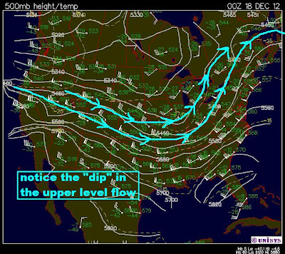
Look at the winds aloft. The "digging" in the middle of the country is the key. It steers the storm system south and back up to the northeast. All the while, it pulls cold air in behind.


Thursday storm will deepen. Temps will climb into the 50s ahead of the front early in the day. Look at the COLD temps behind the front. Expect temps to fall into the lower 30s by early evening

The storm will head into Michigan by late afternoon. the "R" is the rain. The "S" is the snow on the back end.
Preliminary snowfall projections show a good accumulating snow across more than 80% of Northeastern Ohio by Friday afternoon. The "C" is Cleveland. The "A" is Akron. Check the legend on the right for the amount that represents your town.  A lot can change. Lake Erie winds will complicate the snowfall projections so look for more updates right here!


Thursday, December 13, 2012

This Pattern IS Different than Last Year. What Will it Mean Next Week?

Facebook and twitter ave been flooded with many "snow skeptics" as I like to call them. Over the last 2+ weeks, I've been harping on this pattern being very different than last year's pattern. Yet the "snow skeptics" come out of the woodwork and quickly squash any talk of snow saying that "they will believe it when they see it."  The ever popular recency effect comes into play yet again.  That is, whatever is most recent in our minds is held in higher regard than more distant memories. 

Remember those winters of 2002 to 2010? Most of these winter feature above normal snowfall. We were groomed psychologically to expect another repeat last year. That didn't happen. Now we are groomed to think "snowless winter" for this year even though most of our recent winters have featured decent snow.

So how is this year's pattern different than last winter in early December?  Look at the upper level pattern from last December. The ridge deepened in the east keeping the trough and colder air out west.


Now look at the pattern on the 10th. The trough is deeper and further east and stronger.


The outlook for December 21st starts to show the colder and potentially snowier signs we've been hinting at. Remember that each red area is a potential storm system. Look at how flat the upper level flow becomes shortly before Christmas.


This isn't a guarantee that this pattern will continue. But the pattern has been VERY consistent. If this verifies, the chances of snow before Christmas will be very good. 

Monday, December 10, 2012

Where is the Snow? Is this Unusual? A Look Back Gives Us the Answer

This is the biggest asked over the last week or so on Facebook and Twitter. Christmas is 2 weeks away and most people want a bit of snow. Yet we still remember last winter where hardly any snow fell in November and December (2.1") Is this all that unusual?

Here are the snow totals for each winter since 1990 through December 15th.  There are 8 winters with less than 2 inches of snow through the 15th and 9 winters more than a foot of snow since 1990.


The average since 1990 has been 7.1 inches through December 15th...All-time average through the 15th is 9.6 inches...

So we are definitely BELOW THE AVERAGE.  Yet there are many years where the snow totals through mid December have been fairly small.

Why do I continually "strongly hint" at a white Christmas? Two projections have been painting a bulls eye over the northern half of the US the week leading up until Christmas for more than a week now.

No snow this week...

Three separate "run throughs" of this model suggest several inches for Ohio!

Friday, December 07, 2012

Remember Dec 2004's Dramatic Shift? Super Mild to Super Cold

2004 is far enough from back in time to where most of us now need some event from that time to jog our memory. So when I talk about December of 2004's weather, unless you were caught in a snowstorm or knew someone who gave birth that month back then, you're probably asking me "What is so special about December of 2004"?

This month marked the beginning of the snowiest winter in Cleveland history! The event that jogs my mind from this month was that I mowed my lawn on December 4th that year. December 2004 featured a VERY slow start to the winter. Hardly any snow through the 10th. Guess what happened after that?

35 inches of snow through the end of the year!!!

How about the temperatures from that month?  Here is the first and second week. Notice the warmth across the country:

Now watch what happened from the 15th through Christmas. Look at the deep cold across the east and Ohio.

I'm not saying this will happen this year but what I am saying is that the pattern has, in the recent past, performed a complete 180 degree flip. So those of you wondering where the snow is?  Its coming....just a matter of time!

Thursday, December 06, 2012

US Snowcover 2012 vs Last 5 Years

One element of our weather that has been lost in the aether somewhat (as we track the cold air over Canada) is the lack of snowcover across the country.

So  far, as of December 5th, the US was covered in only 7.2% snowcover compared to last year when the snowcover was at 32%

Below is each snowcover map for the US going back to 2008. Given the pattern ahead, I think this years number will go up!

Monday, December 03, 2012

Are December Highs in the 50s and 60s Happening More in Cleveland?

The 8day forecast has been calling for a few strong surges of warm air followed by strong cold fronts over the last 2 weeks. While we ignore the colder intrusions, we relish and remember more vividly the unseasonable temperatures. After all taking your jacket off in December is more memorable than shoveling a few inches of snow.


It is these type of extremes that brings out the Recency Effect in all of its glory. I wrote a post on Facebook last week on this effect. Here is what I said:

"...We succumb to the cognitive bias called the "recency effect". That is, we the tendency to weigh recent events (warmer temps in December) more important than earlier or past events because they are more fresh in our minds."
Are these 50 and 60 degree high temperatures for early December all that unusual? I dug through ALL of the high temperature records for early December since 1912 and plotted what I found in 20 year increments. (Each year would have been a mess!) The first chart is the number of days with highs in the 50s and 60s for the FIRST week of December. The second chart is the number of days with highs in the 50s and 60s for the SECOND week of December.

Notice that the 50 degree trend has varied much. The 60 degree trend is up a bit but not by much.

Days in the 50s and 60s from DEC1st thru 7th          


This second chart shows the second week of December. It stands to reason the number of days would be smaller especially SINCE 1992! In fact, we haven't have a daytime high above 60 AFTER DECEMBER 8TH in over 20 years!

Are 50s and 60 degree high temperatures in early December all that unusual, The quick answer is...NOT REALLY. If I have a chance tomorrow, I will try to plot the number of days for each year. It'll be messy...