Weather forecasting is like playing a round of golf. Sometimes you hit a great shot. Maybe a 40 foot putt or a 190 yard approach shot 3 feet from the cup. The feeling is tremendous! Your the man! You can conquer ANYTHING! The adrenaline rush is euphoric. Then comes the next hole. You tee off and shank the ball into the woods another zip code away. That adrenaline rush is quickly replaced with the dejected feeling of failure.
Last winter, the feeling of failure was palpable in early December. I cautiously called for a few quick snows but the pattern different cooperate. Like my golf game, my tee shots were in the woods. I learned from my mistakes and promised to apply what I learned to this winter's forecast. So far, my prediction of a pattern reversal later this month feels like a 40 foot putt and a 190 yard approach shot all rolled into one. It feels great. So let me ride my wave of euphoria. Let me bask in the glory of my accurate forecast I tweeted and "Facebooked" weeks ago. Let me enjoy it. Let me brag a little...ring my own bell. Because like golf, weather forecasts have a tendency to humble you REAL FAST...knock you down to size. So in the back of my mind, I know the other shoe will fall....at some point.
Now to the the weather and the snow potential for Christmas.
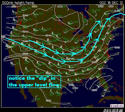
Look at the winds aloft. The "digging" in the middle of the country is the key. It steers the storm system south and back up to the northeast. All the while, it pulls cold air in behind.
Thursday storm will deepen. Temps will climb into the 50s ahead of the front early in the day. Look at the COLD temps behind the front. Expect temps to fall into the lower 30s by early evening
The storm will head into Michigan by late afternoon. the "R" is the rain. The "S" is the snow on the back end.
Preliminary snowfall projections show a good accumulating snow across more than 80% of Northeastern Ohio by Friday afternoon. The "C" is Cleveland. The "A" is Akron. Check the legend on the right for the amount that represents your town. A lot can change. Lake Erie winds will complicate the snowfall projections so look for more updates right here!


