Lots of colorful 👇 charts here so be prepared!
We were coming off of an extremely wet April. Temperatures were slightly above normal. 7 of the last 10 days had measurable rainfall. Back in late April the changes in the tropical Pacific (SOI drop), northern Atlantic (negative NAO) and Bering Sea Low pressure were strongly pointing to a cooler than normal start to May.
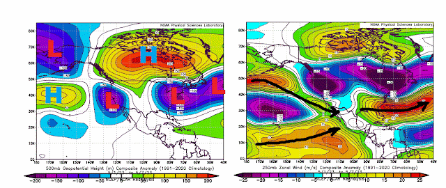
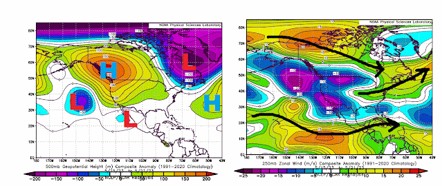
The upper level pattern in 7 day increments: 500mB (18,000 feet on left) Jet stream on the right featured an active west-to-east storm track left over from late April.
 |
| May 1 to May 7 |
By the second week of April, the ridge over central Canada shifts west and south.
 |
| May 8 to May 14 |
Notice the split flow which emerged in the middle of the month. Storm track along the southern border and west to east through central Canada and into New England.
 |
| May 15 to May 21 |
By the final week of May, two pronounced jet stream tracks kept storm systems away from the central keeping the mid-west and corn belt very dry.
Overall temperatures west of the Mississippi and in the upper mid-west were above normal.
The center of the heat was in western Canada.
The split flow kept a large portion of the central US, deep south and Great Lakes extremely dry.
In northern Ohio, we had rain to start the month which skewed the overall totals. 25 of the 31 days were dry.
Temperatures in northern Ohio were slightly below average. We had more days below than above. Days in grey were a degree to either side of average.
By far the biggest element was the lack of humidity.
In fact, April had more humid periods than May.
We average more than 105 total hours of high humidity in May. We ONLY had ONE HOUR! Only 1966, 67, 68 and 1971 compare.
April and May high humidity periods (total hours) compared to past years.
The average northern Ohio humidity in May was the 3rd lowest since the last 1940s.
Severe storm warnings were non-existent in Ohio and surrounding states compared to April.
What about June? On May 22nd, the tropical Pacific indicated a HUGE drop in the SOI. Using the historical analogs, the "less humid & dry" pattern looks to continue through the middle of the month. The projections on June 2 were latching onto this idea bigtime.


