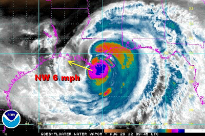
First, let me address one item before we dive into the meteorology of Isaac. Many are saying that the media is over-hyping Isaac. To this I say, ABSOLUTELY NOT.
While I am very critical of the media's handling of weather stories, hurricanes or tropical storms are a different matter. These storms are very large and the impact can be felt across several states at a time. Too often, people fixate on the wind speed and wind gusts as a gauge on how damaging the storm will be in any one location. Yet rainfall and flooding are often overlooked as major damage contributors. My theory is that because flooding events are so hard to quantify and even harder to forecast locally, our minds don't process hearing a forecast of 5 to 10" of rain. A wind speed forecast of 80 mph hit our brain like a lead weight and drives home the story faster and harder. Only after we see video or pictures of the areas flooded does it sink in. The fact that Isaac delayed the Republican National Convention makes it seem more significant. Isaac was on the news a week ago so we were primed for hearing the name "Isaac" when it was 500 miles away. More importantly, Isaac is hitting a major US city which lies below sea level makes the situation potential worse than if it hit Miami.
My point is that rainfall and subsequent flooding from ANY TROPICAL SYSTEM regardless of the wind speed can be deadly. We can never underestimate or under report any tropical storm! Yes, Isaac is no Katrina. The characteristics of Isaac are far different than Katrina. The direction of moving is different. By Thursday, the flooding will no doubt be as destructive for many of the same areas hit by Katrina exactly 7 years ago.
Now to the weather. Why has Isaac slowed down?
The high pressure ridge north of the gulf coast centered over the mid west and the Great Lakes is pushing south and east deflecting the movement of Isaac west. The steering currents are not favorable for rapid movement inland. So Isaac continues a Northwest crawl at 6 mph.
Compare this setup to Katrina. Notice the trough in the middle of the country. The steering currents were perfect for a northerly trek inland
Wind direction around the storm and into the shoreline is from the southeast and east. A report of 110 mph gusts Bayou Gauche from St. Charles Parish EOC. This direction funnels gulf moisture right into New Orleans and surrounding areas making the flooding threat greater even with the lack of Katrina-like winds.
A close up of the wind field around Isaac really tells the story on how the southeasterly winds pull gulf moisture right onto the shoreline.
Here is a great map showing the rainfall as of 8AM Wednesday which is approaching 10 inches.
New Orleans more than any city in the US is the most susceptible to flooding because it sits below sea level. Here are a few streets elevation compared to how they sit relative to the sea. The map is not to scale.
Now you see why the media can't emphasize tropical storm/hurricane landfalls near New Orleans enough.


1 comment:
Thank you so much for this blog. I love how you make things so easy to understand. Do you still think we will get the rain Sunday,considering Isaac is not moving much?
Post a Comment