Tuesday, December 31, 2013

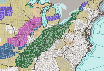
Winter Storm Watch New Years Day/Thursday

A series of clipper snows have affected northern Ohio over the last 24 hours which amounts to several very dry inches of accumulation. Most of this will move out later today.

The bigger snow system is developing now...CURRENT RADAR LOOP HERE


The initial push of light snow will approach later tonight and early Wednesday. Accumulations through noon tomorrow will be around an inch or two. The storm itself begins to rotate southeast then more due east. It will take a while for the snow to converge along the front. Once that happens, the heaviest snow will affect northern Ohio Wednesday evening and overnight.

Winter Storm Watch in effect from Wednesday 7AM to Thursday 7AM for the following counties:

A WINTER STORM WATCH means there may be hazardous winter weather due to heavy snow. Heavy snow means 7 INCHES OR MORE of accumulation in 24 hours or less. They are issued at least 12 hours (sometimes 24-36 hours) before the hazardous winter weather is expected to begin. 

When the storm becomes imminent (inside 12 hours of occurring) or has a high probability of occurring, watches are upgraded to a "WARNING" which was done yesterday for select counties.


Initial snowfall projections are as follows. The track of the storm and its speed will determine if these numbers need to be adjusted later today and this evening.


Saturday, December 21, 2013

Heavy Rain Continues; River Flood Forecasts for Northern Ohio


SEVERE THUNDERSTORM WATCH FOR SOUTHERN OHIO UNTIL 3AM


Current radar loop shows widespread rainfall across not only Ohio but across the Ohio Valley. A line of storms will push though southern Ohio. Some storms are possible across portions of northern Ohio. LOOP AT THIS LINK


Rainfall amounts will be between 2 and 3 inches in many locations.
The initial flooding was due to snow melt which amounted to between 1/2" and an 1"+ of liquid. Now with a good 2" of rain today and tonight rivers will rise rapidly. Here are some river forecasts for northern Ohio. Most river will peak late Sunday and Sunday night.

HURON RIVER AT MILAN
KILLBUCK CREEK
BLACK RIVER AT ELYRIA
GRAND RIVER AT PAINESVILLE
CHAGRIN RIVER AT WILLOUGHBY
CHAGRIN RIVER
CUYAHOGA RIVER AT INDEPENDENCE
TUSCARAWAS RIVER IN MASSILLON
CUYAHOGA RIVER IN AKRON


Wednesday, December 18, 2013

Heavy Rain & Flash Flood Forecast

FLOOD WATCH FOR PORTIONS OF 10 STATES
FLOOD WATCH GOES INTO EFFECT FOR MOST OF OHIO FROM SATURDAY MORNING UNTIL SUNDAY EVENING...

Temps will slowly rise into the 40s with a possible 50+ by Sunday. The boundary between the milder air and the winter cold push next week will be very close to northern Ohio.

A stalled front will set up shop along the sharp temperature boundary. Rainfall will be heavy and extensive across the midwest and Ohio.
 
 Initial projections give northern Ohio over 2" by Sunday afternoon.
What about flooding? The snow cover is anywhere from 3 inches south up to a foot in the snowbelt. The liquid equivalent of the snow is around an inch to locally higher amounts.

6 hour Flash Flood guidance for Ohio shows we would need at least 2 inches of rain over a 6 hour time to create flash flood conditions. This does not take into account the snow melt however.

Combining the snow melt and the heavy rainfall, the National Weather Service has included much of Ohio in a "Potential Flash Flood" area for late Sunday. 

Here are some river water stage forecasts for the next 10 days. All rivers below except the Tuscarawas River near Massillon show minor flooding late Sunday into Monday. For current forecasts, here is the site RIVER FORECASTS

Cuyahoga River at Independence - Peak early Monday 12/23

Grand River at Painseville - Peak Sunday night 12/22
Huron River at Milan - Peak Sunday morning 12/22

Tuscarawas River at Massillon - Peak late Sunday through Tuesday

Monday, December 16, 2013

Does Our Snowy Start Mean A Snowy Winter Overall?


Marblehead Lighthouse

The collective belief that this winter will be super-cold and snowy is loud after the recent snow and long period of colder than normal temperatures.  While the drivers of winter are pointing to this season (December through February) being colder and snowier than average, a cold and snowy start (late November and early December) doesn't always carry over.

Look at the snowfall totals by December 15th since the early 1950s. 2013 is on the far right with 15 inches so far. Most winters we have well below 15 inches by December 15th going back to the early 1950s. I highlighted the snowiest winter (2004-05) and the winter of 1977-78 which was made memorable because of two historical blzzards in January.


 Here is the list in order from top to bottom. Surprisingly, 2013 is 14th on the list since 1954


How much snow did we end up with at the end of the winter in the years which had the same or more snow on December 15th?

8 of the 13 winters had final snow totals BELOW THE AVERAGE of 68 inches!


This is a purely statistical comparison as the dynamic drivers of many of these winters are totally different than the current drivers and conditions. What does all of this show?  It illustrates that we shouldn't be fooled or convinced that this winter will be snowier based on what has happened so far.

Anything can happen.

Saturday, December 14, 2013

More Snow On The Way Saturday

UPDATES ON MY SOCIAL NETWORKING PAGES THROUGHOUT THE WEEKEND:

FACEBOOK: https://www.facebook.com/ScottSabolFanPage
TWITTER: https://twitter.com/ScottSabolFOX8
GOOGLE+: https://plus.google.com/u/0/+ScottSabol/posts
INSTAGRAM:  http://instagram.com/scottsabolpics#

CURRENT RADAR IMAGE - LOOP LINK HERE
This snow event is the real deal. I know. I know. Everyone is saying "Weren't were supposed to have a lot of snow this morning?" Not to worry, its coming later today as we forecasted yesteday.

This panhandle low is much different for two reasons: COLD AIR IS ALREADY ESTABLISHED and THE MOISTURE AMOUNTS ARE SIGNIFICANTLY HIGHER than with the last two. The moisture originates from the tropical Pacific. The conveyor belt of moisture continues to feed the Texas panhandle low.

Give all of the parameters, the snow will be WIDESPREAD and heavier. It will be much harder to shovel. We are not anticipating much wind with this snow. Some lesser amounts along the shoreline where the relatively warmer waters will cause some initial melting.


Friday, December 13, 2013

Widespread Snow for OHIO Saturday!!!

UPDATES ON MY SOCIAL NETWORKING PAGES THROUGHOUT THE WEEKEND:

FACEBOOK: https://www.facebook.com/ScottSabolFanPage
TWITTER: https://twitter.com/ScottSabolFOX8
GOOGLE+: https://plus.google.com/u/0/+ScottSabol/posts
INSTAGRAM:  http://instagram.com/scottsabolpics#

CURRENT RADAR IMAGE. LOOP HERE
This snow event is the real deal. I know. I know. Everyone is say "What happened to the other two snow events?" The temperatures were warmer and the moisture was shifted much further east.
Small scale conditions like a shift a few degrees in temperature can make the difference between snow and sleet reducing the snowfall amounts. In hindsight, initial amounts (24 hours out) were too high. Inside that time frame, we adjusted them accordingly. This is why we can't handle probability in weather forecasts.  We crave a concrete forecast. All too often, it doesn't work out. 

Now back to the snow for tonight and tomorrow (Saturday)...

This panhandle low is much different for two reasons: COLD AIR IS ALREADY ESTABLISHED and THE MOISTURE AMOUNTS ARE SIGNIFICANTLY HIGHER than with the last two. The moisture originates from the tropical Pacific. The conveyor belt of moisture continues to feed the Texas panhandle low.


 The moisture converges and slides right over the Midwest over the next 24 hours.


The high resolution WRF model shows the snow rapidly intensifying over the next 24 hours. The forecast bring the snow into northern Ohio, Indiana, Illinois and western Pennsylvania tonight into Saturday. Video of this is below:


A close up really shows the extent of the snow by 2AM Saturday.


Give all of the parameters, the snow will be WIDESPREAD and heavier. It will be much harder to shovel. We are not anticipating much wind with this snow


The probability for more than 4" is greater than 80% as per the National Weather Service.


Wednesday, December 11, 2013

Will The Cold Lead to More Ice On Lake Erie?

Totally Ice Covered Lake Erie in 2011

Here are my other blog posts over the last two winter about Lake Erie Ice Cover and temperature trends, lake effect snow:

http://sabolscience.blogspot.com/2012/02/valentines-day-update-any-ice-on-lake.html
http://sabolscience.blogspot.com/2012/08/will-warmer-lake-increase-lake-effect.html
http://sabolscience.blogspot.com/2012/01/where-is-lake-erie-ice-will-it-freeze.html
http://sabolscience.blogspot.com/2013/10/will-warm-fall-slow-cooling-of-lake-erie.html

===========================================================

Since the beginnings of this abnormally cold winter pattern about a week ago, people have asked what the ice conditions were on Lake Erie. Not surprisingly, the amount of ice coverage on the lake is about 1%, most of this is in the far western basin of the lake where the water depth is very shallow.

Overall Lake Erie Ice Concentration on 12-11-2013
Far Western Basin Lake Erie Ice on 12-11-2013
A recent photo from the south side of Kelleys Island confirms that ice is forming in other spots too in the western basin.


This is not all that unusual for this time of year. When we look at each winter since the early 1970s by December 11th, only 4 times has Lake Erie had more than 5% ice cover in the middle of December!  Environment Canada has a great website with all sorts of ice information for the Great Lakes.


The current conditions are lining up fairly well with ice cover averages for Lake Erie. The first red circle below shows little ice for mid December with a peak in early February.
 

Many conditions have to be present for ice to form on Lake Erie to include sustained cold air temperatures. If frequent storm systems pass over the lake featuring strong winds like we've had, the upper layer of water will be continuously stirred and overturned. This overturning causes mixing of different layers of different temperatures. In these conditions, widespread ice formation is difficult in the short term. Long term trends indicate that Lake Erie ice cover is showing a decrease of -0.74% per year. This is the smallest decrease of any Great Lake according to research.

Recently, the water temperatures have begun to drop in the upper 30s.

 A more high resolution look from Michigan State's Remote Sensing image shows spots falling into the lower 30s especially in the western basin.

Water temps are still markedly warmer closer to Cleveland and the eastern shoreline.

While the lack of ice cover currently is pretty normal per the 40 year averages, the colder pattern for early December is unusually strong nationally compared to recent years. IF this colder pattern continues into the beginning of January with a 8-10 day stretch of daytime highs in the lower to mid 20s with cold overnight lows without significant wind, Lake Erie will start to accumulate ice at an increasing rate.