TORNADO WATCH still in effect for all of northern Ohio until 12AM. This means CONDITIONS are still FAVORABLE. No confirmations of any touchdowns in northern Ohio. Watch might be cancelled before 12AM. Stay tuned...
CHECK OUT MY TWITTER FEED FOR ANY WARNINGS ISSUED
Earlier today, updates here projected the main line of storms to be approaching western areas of Ohio by 6PM. Here was this initial map created by the HRRR model.
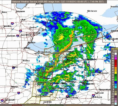
Here is the radar image at 8PM...line is moving a bit faster CLICK ON THE RADAR IMAGE FOR THE CURRENT RADAR LOOP OVER OHIO
Between 8 and 10PM, expect fast moving (50-60 mph) storms across northern Ohio. Some will be severe
By 10PM, the majority of the storms should be out the area...
Notice the temperature drop behind the front circled in BLUE.
We'll wake up to temps in the lower to mid 40s Monday morning.


No comments:
Post a Comment