Showing posts with label winter weather. Show all posts

Thursday, October 22, 2015

Winter Temperature Trends in Ohio (Midwest)


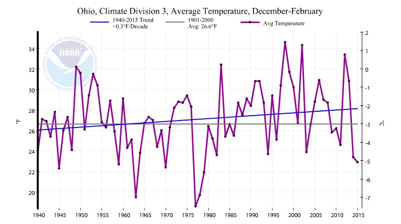
The National Climate Data Center has a great site for graphing the many climate divisions and climate regions across the U.S. So I plotted the winter (December through February) average temperature trends for various regions around northern Ohio since 1940. I chose 1940 because prior to the late 1930s, the official NWS temperature reading was taken at various locations throughout the Cleveland area. Since 1940, Hopkins Airport has served as the official NWS temperature location.

Notice the very cold winters of the early 1960s, late 1970s, highly variable winters of the 1990s and early 2000s and the last two cold winters at the far right side of the graph.

Overall, the trends are similar with each graph showing winter temperatures more consistently above average since the early 1980s. The overall warming trend however amounts to a tenth to a few tenths of a degree per decade in Cleveland and surrounding climate divisions and outside regions.

Note: My only aim is to show the past winter temperatures (December through February) with NCDC data. Nothing more. Nothing less.

ENTIRE STATE OF OHIO


 Ohio climate divisions:


NORTHEAST OHIO
NORTH CENTRAL OHIO
 
MANSFIELD, ASHLAND REGION


CORNBELT


OHIO VALLEY: OH, IN, IL, MO, KY, TN, WV


Thursday, February 24, 2011

BIG SNOW for Friday, February 25th

After the snow early this week, its understandable if people start to question our snowfall predictions. I heard it from friends and family alike:  "What happened to that 1-3 inches you talked about this morning?"  I can feel it even now. A blanket of "forecasting cynicism" hangs over the area like a thick layer of fog.

Honestly, I understand why everyone reacted this way.  The snow hit right before rush hour.  Viewers were mad.  Kids were mad.  Everyone was mad, testy and probably hungry after a 3 hour ordeal in the car, stalled in traffic with no end in sight.  If I wasn't working, I probably would have had a few choice words too.

But not to worry.  Another major winter storm is heading this way.  In an effort to be vindicated from my latest forecasting mishap, (my dad called it a debacle"), I am here to present ALL POSSIBLE FORECASTS relating to this upcoming blast of late season winter slop.

Three different computer simulations are cranking three different snowfall projections. The last map is our consensus. Hopefully it works out...

Excuse my sarcasm...:)


Monday, January 31, 2011

Major Midwest Snowstorm Developing

...This storm will occur in two waves.  The first is wet snow Monday night into Tuesday.  Here are the initial snow amounts.


30 states under some sort of WINTER WEATHER WATCH OR WARNING

The FIRST WAVE of winter weather develops overnight tonight. WET SNOW into TUESDAY


The SECOND WAVE develops TUESDAY NIGHT into WEDNESDAY AM. Winds Wednesday morning could exceed 30-40 mph


Tuesday, December 28, 2010

The Best Winter Timelapse EVER!

This was taken by Michael Black. whose videos/timelapse photography has been featured on television many times.  This video was taken over 20 hours with a picture taken every 5 minutes.  ENJOY!

December 2010 Blizzard Timelapse from Michael Black on Vimeo.

Monday, December 13, 2010

Round #2: Lake Effect And the Arctic

How the patterns have changed.  November was great.  No winter weather.  Milder temps.  Now another big round of lake effect snow; the second one in a little over a week!
CLICK HERE FOR NE OHIO RADAR
 Why the big change?


Let check out the temps compared to normal for November.  Fairly mild and uneventful.


 Most of us thought we'd make it well into December without getting lake effect.  We thought wrong!

Why the sudden change?

If you remember our winter weather outlook back in early November, we hinted at a HUGE dramatic change in the weather pattern in December and January driven by La Nina and the Arctic.

The pressure systems over the arctic change randomly. In the winter, those changes are more pronounced.

Below is a picture of how the temperatures over the arctic change the movement of the storms over the US and northeastern Ohio.  When the arctic is "NEGATIVE", it steers storms and cold air south just like our weather over the last week.
The arctic has "dipped" negative several times since September but no big weather changed occurred. 


This last "dip" in December is significant. Notice the temperatures so far compared to average.


The arctic has the potential to get more "negative" pushing COLDER AND COLDER AIR SOUTH through Christmas and the New Year.


Looking back at the DECEMBERS (17 Decembers total since 1950) in which the arctic was this strong this early in the season, we find that the temperatures are WELL BELOW NORMAL.


THE BOTTOM LINE:  LOOK FOR THIS COLD AIR AND FREQUENT LAKE EFFECT SNOW TO CONTINUE AT LEAST THROUGH CHRISTMAS AND POSSIBLY INTO EARLY JANUARY

Thursday, December 09, 2010

Sunday Storm Update - Thursday morning, Dec 9th

 Sunday's storm appears to take a northerly track--at the time of this writing, Thursday morning.  If this track is accurate, we get a rain/snow mix and less accumulating snow


I can guarantee super-arctic air Monday and Tuesday with big lake effect snow!


Tuesday, December 07, 2010

HUGE East Coast Snowstorm this weekend!

Snow totals as of Tuesday at 10:30AM from the National Weather Service in Cleveland. This covers 2 days of lake effect snow. Click on image below for larger look.


A major east coast snowstorm seems to be developing Sunday into Monday this weekend.  As temperatures warm into the mid 30s Saturday, the snow will be a heavier, wet snow compared to the fluffy, lake effect snow of the last several days. Get ready for ANOTHER ROUND of LAKE EFFECT MONDAY NEXT WEEK!


Monday, December 06, 2010

First of Many Arctic Cold Intrusions...Lake Effect Snow

The first lake effect snow event is here and its staying over Northeastern Ohio until early Wednesday.

Here is a photo my mom took in Hudson early Monday morning.


Winds out of the northwest is pulling moisture from Lake Erie, Lake Huron AND Lake Michigan producing widespread lake effect snow across Cleveland and northern Ohio.


Lake effect snow warnings for MEDINA, CUYAHOGA, SUMMIT, PORTAGE AND THE ENTIRE SNOWBELT until late Tuesday.

As we talked about in a previous post, cold air like this will be very common in December.  Here are the forecast temperatures for Tuesday and next Monday.  Notice it gets COLDER next week. EXPECT THIS COLD AIR TO CONTINUE THROUGH CHRISTMAS.


Wednesday, December 01, 2010

Last Look at Hurricane Season...-40 in Alaska!

A taste of what is coming for the eastern half of the US and northern Ohio later this winter, especially in January and February...

NASA has just found the first -40 degree temperature of the season yesterday over interior Alaska. This satellite (The Advanced Very High Resolution Radiometer) is a radiation-detection imager that can be used for remotely determining cloud cover and surface temperatures by collecting different bands of radiation wavelengths.The coldest regions are shown with the purple/pink areas on this image.  Note: The image is not oriented from north to south.


Just a few random items I recently read about hurricane season courtesy of NOAA and NASA.  Read ahead and check out the images below showing the rainfall from the 2010 season compared to the record setting 2005 season:

The year 2010 was accurately predicted by the National Oceanic and Atmospheric Administration (NOAA) to be an active one with 14-23 tropical cyclones and 8-14 hurricanes predicted. NOAA's National Hurricane Center (NHC) in Miami, Fla. subsequently named 19 storms with 12 reaching hurricane strength.

The 2010 Atlantic hurricane season was the most active since the record breaking season of 2005. Hal Pierce of the Tropical Rainfall Measuring Mission, or TRMM satellite team at NASA's Goddard Space Flight Center in Greenbelt, Md. created a comparison between the tropical cyclone rainfall occurring in 2005 and 2010. These tropical cyclone rainfall analyses were both made at NASA Goddard using TRMM-based, near-real time Multi-satellite Precipitation data (TMPA).TRMM is a joint mission between NASA and the Japanese space agency JAXA.

The rainfall stayed offshore in two areas this year.

 In 2005, the rainfall was centered over the Gulf of Mexico, Cuba and Florida

Monday, November 29, 2010

Cold Period Upcoming...Get Ready!

We are living on borrowed on "weather time" so to speak.  Temps have trended above normal in Cleveland for most of November.  Now, the pattern is about to make an abrupt change.  This change will more than likely entrench itself through the first two weeks of December.

What do we look at when trying to find these changes from a warm pattern to a cold one?

The first indicators are from way up north in Canada, the North Pole and Russia.  As the highs and lows travel around the earth, they often get into a pattern.  Recently, the highs have been present over the eastern US.  Over the next several weeks, the highs are shifting to the west and the lows (troughs or fronts) are replacing it.  The center low is over northern Canada.  This "Canadian Low" acts as the "center of the wagon wheel" swinging down "Alberta Clippers" with widespread small snowfalls.  See the graphic below.

The "warmer" pattern has held off the formation of ice over Hudson Bay
As the pattern changes, the front will be deeper and stronger with lots of cloud cover.


Here are the temperature trends for early this week and into the weekend for the US and Canada.  Notice the "32 degree" marker well north of Ohio in the first graphic then well south in the second.  Much colder for sure!

The bottom line is colder than normal air will stay around through the weekend and into most of next week.  When the snow flies, it will probably accumulate and stay on the ground for a while across most of Northeastern Ohio.

Winter is coming!

Friday, November 19, 2010

Cold Air and Snow for Thanksgiving Weekend?

We all knew it was coming.  Temperatures have been way too warm for way too long.  This happens in November every year it seems.  We are teased into thinking that winter won't happen or that it'll be delayed for some extraordinary amount of time, maybe until January.  In reality, it never works out that way.

At this time last year, temps were somewhat warm.  This map below is a birds-eye view over the North Pole looking at the surface temperatures.  Northeastern Ohio is on the far left as we look south (to the right). Notice as the temperatures were warmer here in Cleveland, the cold air was building over the north pole.


By Thanksgiving and into the first week of December, pieces of this arctic air began to break off and seep south into Asia and Canada.


By the middle of December, arctic air was pushing into the northern half of the US.


This upcoming week--like a trip to the dentist--will be the wake up call we all knew was coming.  Just like last year, cold air is building over the north pole and Siberia.  All it will take is a strong cold front to extract that cold air sliding into the eastern US and northeastern Ohio.  Here is how I think it will shake down.


Late this weekend into Monday, temperatures will start to climb quiet a bit.  Notice the cold air starting to push south at the top of the following map. (Maps courtesy:  Intellicast.com)


A strong cold will push east late Tuesday into Wednesday producing some rain and gusty winds.

Today (Friday), cold air is slidding over Hudson Bay and is visible with the lake clouds its created on this visible satellite loop (Click image for the animation).


By Thanksgiving, temps will start to fall somewhat...cold enough for some wet snow late.


By Friday and Saturday, the air gets cold enough for Lake Effect snow with a series of Alberta Clippers thrown in for good measure.


The bottom line:  Late next week and into the first half of the Thanksgiving Weekend, many spots around Northeastern Ohio will have a good amount of snow on the ground.  Expect flight delays and slick road Friday and Saturday.