Showing posts with label akron. Show all posts

Tuesday, May 21, 2019

Spring Rainfall/Temperatures/Cloud Cover

April/May 19th cloud cover for each day in Cleveland and Akron

* Bottom of each graph is the ground. Top of graph is 30,000 feet
* Light blue color indicates clear skies
* Black/Grey color indicates cloud cover

Notice more cloudy days this year compared to last year over the same period. Also, Akron has had less cloud cover overall.


CLEVELAND: April-May 2018
CLEVELAND:  April-May 20, 2019

AKRON:  April-May 2018
AKRON: April-May 20, 2019
Mid April-Mid May: Ohio rainfall and temperatures vs normal since 2015

2019

2018

2017

2016

2015


Thursday, October 22, 2015

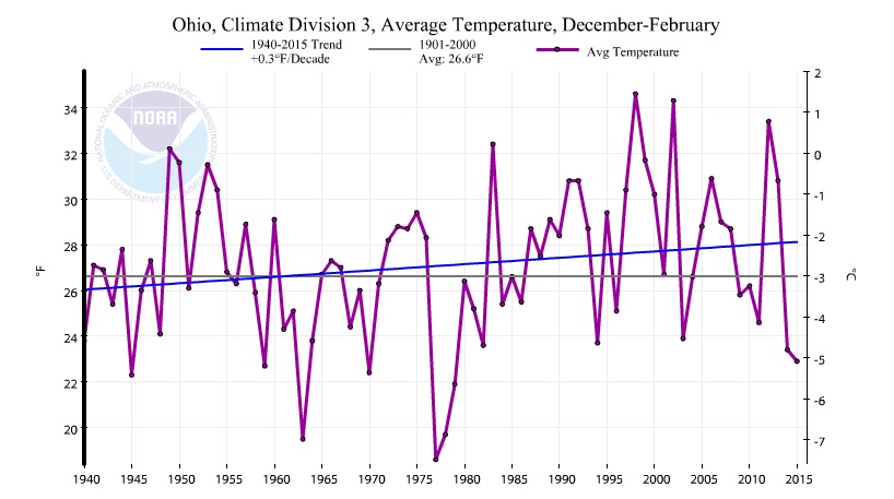
Winter Temperature Trends in Ohio (Midwest)


The National Climate Data Center has a great site for graphing the many climate divisions and climate regions across the U.S. So I plotted the winter (December through February) average temperature trends for various regions around northern Ohio since 1940. I chose 1940 because prior to the late 1930s, the official NWS temperature reading was taken at various locations throughout the Cleveland area. Since 1940, Hopkins Airport has served as the official NWS temperature location.

Notice the very cold winters of the early 1960s, late 1970s, highly variable winters of the 1990s and early 2000s and the last two cold winters at the far right side of the graph.

Overall, the trends are similar with each graph showing winter temperatures more consistently above average since the early 1980s. The overall warming trend however amounts to a tenth to a few tenths of a degree per decade in Cleveland and surrounding climate divisions and outside regions.

Note: My only aim is to show the past winter temperatures (December through February) with NCDC data. Nothing more. Nothing less.

ENTIRE STATE OF OHIO


 Ohio climate divisions:


NORTHEAST OHIO
NORTH CENTRAL OHIO
 
MANSFIELD, ASHLAND REGION


CORNBELT


OHIO VALLEY: OH, IN, IL, MO, KY, TN, WV


Tuesday, April 07, 2015

First Taste Of Spring Features Frequent Rains

Stalled front across northern Ohio is the focal point for clusters of rain and a few storms. Notice that these rain clusters move fairly fast with dry breaks in their wake. This will be the general weather outlook through early Friday.


Current OHIO temperatures


Current Ohio Valley radar loop
Central Great Lakes sector loop

Monday, March 02, 2015

Where Does This Winter Cold/Snow Rank All-time in Cleveland?

Frozen Tundra covering Lake Erie

The meteorological months of winter are December, January and February. The snow cover across northern Ohio is very deep after the recent snowfall. This endless blanket of the white stuff makes this definition seem, at the very least, misleading and pretty pointless to many of us who still have snow piled up high. When we do meteorological comparisons to past seasons, the three month periods nearest to the season in question is used by climatologists. For example, December through February are the winter months. March through May are spring months and so on.


So how does this winter compare to last winter (colder than average), two winters ago (milder than average) and the coldest winter ever (1976-77) in northern Ohio?  I'll use the same metrics for comparison I've used in the past:   

Average 3 month temperature rank all-time (December through February) since 1871
Seasonal Snowfall
Below zero nights
Days at or above 40
Days at or below 32
Consecutive days with at least one inch of snow cover
Total days with snow cover of at least one inch
Total days with snow cover of at least six inches

Monthly temperature ranks

==============================================================

1) AVERAGE 3 MONTH TEMPERATURE RANK SINCE 1871

Add caption
SIDE NOTES: 

* The only winters that were colder in the last 50 years were:  1976-77, 1977-78 and 1969-70

*  The average temperature from January 1 to February 28th was the 6th coldest EVER, coldest since 1977-78, 4th coldest in the last 100 years, 3rd coldest in the last 50 years

2) Seasonal Snowfall


SIDE NOTE:   

*  This winter's snowfall rank is 14th. Last winter was 9th, Two winters ago was 59th

3) Below Zero Instances


SIDE NOTE:  Only 4 other winters had more temperatures below zero since record keeping began in Cleveland:  1978-79 (14), 1962-63 (16), 1884-85 (19) and 1976-77 (24)

4) Daytime high temperatures at or above 40 degrees


5) Daytime high temperatures at or below 32 degrees


6) Consecutive days with at least one inch of snow cover


 SIDE NOTE: Current stretch now at 40 days as of March 2nd

7)  Total days with snow cover of at least one inch


 SIDE NOTE:  This winter's number of snow cover days is ranked 10th all-time. Last winter was ranked 8th all-time. 

8) Total days with snow cover of at least six inches


9) Monthly temperature ranks since November


Feel free to comment below; any questions always welcome!

Saturday, February 28, 2015

Heavy snow for northern Ohio Sunday: SNOW FORECAST HERE

Heavy wet (packing) snow for Sunday across all of northern Ohio. This is a panhandle low-type system which are more common later in the winter when the seasons start their northerly transition to spring. This system is LOADED with moisture.

WINTER STORM WATCH has been DOWNGRADED TO AN ADVISORY for the counties in blue

WINTER WEATHER ADVISORY mean selected areas are forecast to receive between 4-6 inches of snow in 12 hours.

While the wording of the advisory areas has changed, the snowfall forecast was lowered only slightly


Current radar loops are below.


Central Great Lakes sector loop

Snow will arrive predawn Sunday with the heaviest snow later in the day.

Sunday between 7-9am

Sunday early afternoon
Remember that this system will last a good 12 hours with a few breaks in between.

Heaviest snowfall will be across southern counties. Less snow along the shorelines of  Lake and Ashtabula Counties.

UPDATED SNOWFALL FORECAST THROUGH MONDAY AT 7AM.

FORECAST FROM EARLIER THIS MORNING...


Saturday, May 17, 2014

Weekend Northern Ohio Radar Loops - Temperatures

CHECK OUT THE CURRENT RADAR LOOPS AND CURRENT OHIO TEMPERATURES


Current OHIO temperatures


Current Ohio Valley radar loop
Central Great Lakes sector loop

.


Thursday, January 20, 2011

University of Akron - Winterfest 2011 Photos

I had the privilege of going live from the Winterfest at the University of Akron Wednesday morning. These students and former students are some of the most talented individuals in the area. Below are pictures from the event.