Showing posts with label cleveland fox 8. Show all posts

Monday, March 20, 2023

If the rain this winter was snow how much would we have?

It's a great question.  

After all actual snowfall this winter versus the 20 or 30 year averages was extremely low.  
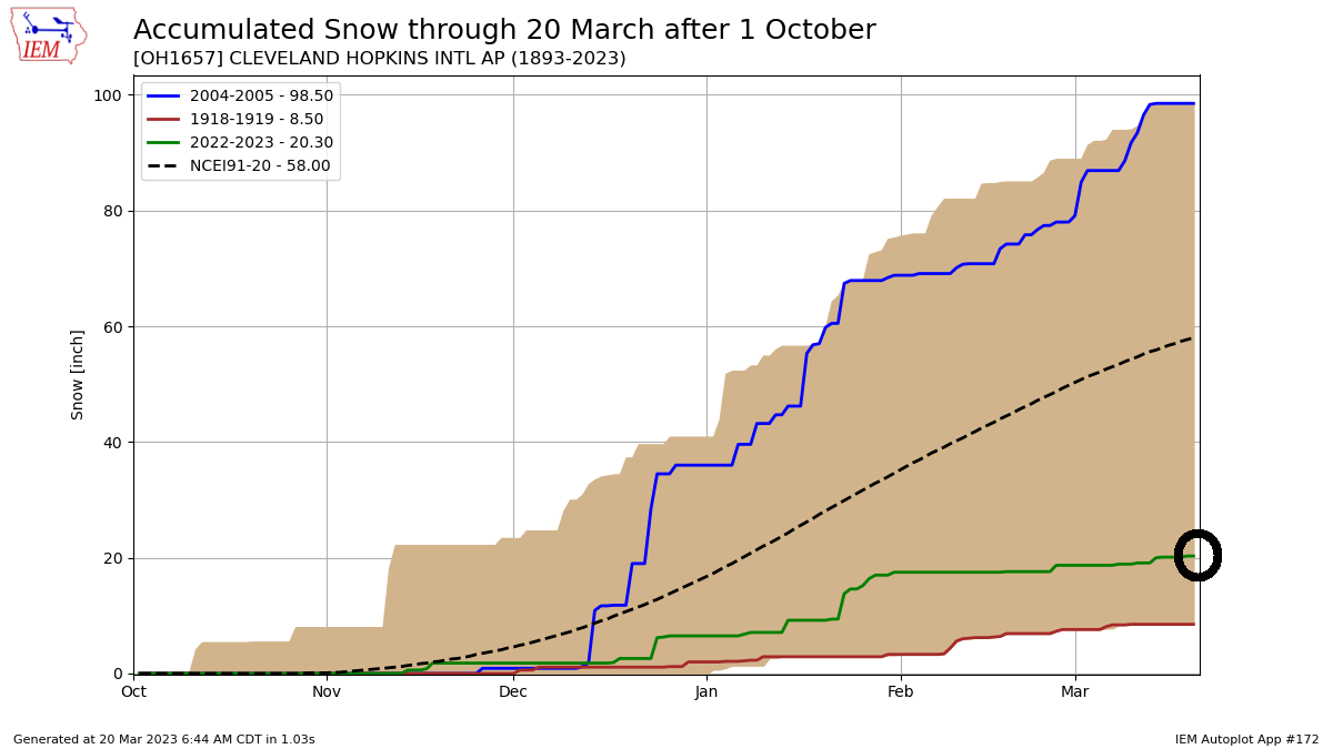

Snowfall as of this writing in Cleveland is barely above 20 inches.  Yet the liquid precipitation (rain and snow combined) is north of 12 inches!


Before we attempt to answer this let's recap the winter storm track. After one of the warmest winters on record here in northern Ohio and across a large portion of the Great Lakes and Ohio valley, storm systems coming out of Texas ended up producing more rain on the southern end of the track with heavy snow staying across the northern states. Total precipitation (rain and snow) was well above normal in areas that saw above normal snowfall vs areas that saw more rain than snow.


Total precipitation from November through December was well below normal. January through mid March total precipitation was well above normal.


So how much snow would all of this precipitation give us if we converted ALL of it to snow?  

Converting liquid precipitation to snow using a (15" of snow to 1" liquid ratio) would give us these numbers (orange) vs actual snowfall (blue).  15 to 1 ratio is arbitrary as wetter snow would closer to 10 to 1 and super-dry snow could be as high as 25 to 1.  I took the middle ground.  The higher the orange line, the more total precipitation thus more potential snow (if converted).


Next we need to find the difference between the actual snowfall (blue above) each winter from the total converted liquid to snowfall (orange) to give us the remaining potential snow.  The larger the difference, the more liquid precipitation (converted to snow) that winter. I plotted each year's difference in the bar graph below.  


The top 10 highlighted below with 2022-23 highlighted for reference.
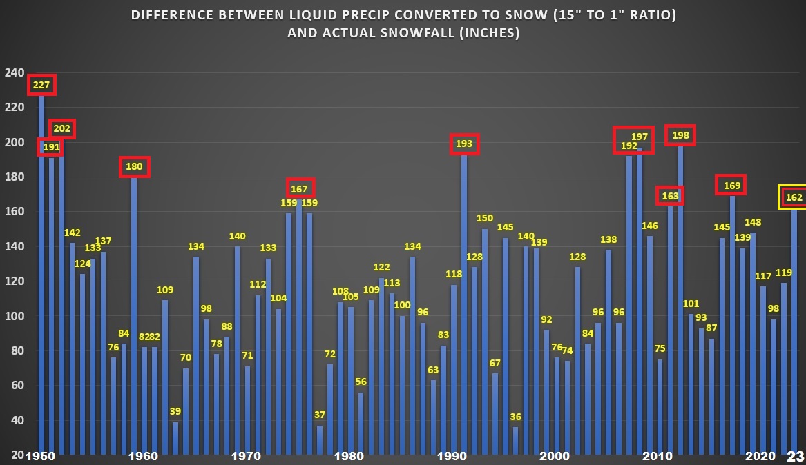

Bottom line is that the winter liquid precipitation (after subtracting the actual snowfall) this winter when converted to potential snow yielded a number just outside the top 10 highest since 1950 (graphic above). This winter had the highest liquid to potential snow since the winter of 2017-18 and a 36% increase comparing this winter to last winter and 65% increase compared to two winters ago. Yet this winter didn't crack the top of the list but its up there. 

1949-50:  227"

1951-52:  202"

2011-12:  198"

2007-08:  197"

1990-91:  193"

2006-07:  192"

1950-51:  191"  

1958-59:  180"

2016-17:  169"

1974-75:  167"

2010-11:  163"

2022-23:  162"

Monday, April 26, 2021

Second Heaviest Snow This Late In The Season. When/How Did We Know?

I'm 5 days late with the late April snow recap.  Here are the snow amounts:  A few locations were close to 8 inches by Thursday morning.

April 21 snowfall

Euclid


Seven Hills

Perry

Snow after March 20 is pretty common in northern Ohio.  Snow after April 20 is a rarity. Only two other years have had more than 2" after April 20.  1974 and 2005. The 2005 event was over a 48 hour period (see the map below).


April 23-25, 2005 snowfall.  Remember this? More than a foot of snow fell across a large part of northern Ohio.  In 3 days it was completely gone!


Signs were pointing to snow or at least a deep storm system with colder air back on April 5--two week prior.


The MJO was heading into favorable cold phases.


A recurving typhoon near the Philippines (which often times portends cooler than normal temperatures eastern US) gave us another good indication.


Eventually the long range models (back on April 8) picked up on this colder idea.

Animation of temperatures: April 10 to 22


Upper level pattern was pretty close to April 2005 snow event. That storm system was deeper.


What's the latest we've had snow? After cross-referencing hourly temperature data, the years are narrowed down to only a few.  Last year was the LATEST MEASURABLE SNOWFALL which broke the record set back in 1907.  Flurries were reported close to Memorial Day in 1907 and 1961 (Akron).


How quickly after late season snow do we see an 80° degree day? Earlier in April it took us around 7 days (6 days listed below) post snow to reach 80°.  Snow on April 1.  83° April 8.


Indications of a late month warmup were surfacing shortly after the colder mid-month pattern was showing up.  SOI composites (analog to similar situations in a La Nina) showed a weak, short-lived ridge of high pressure/warmth around April 26th.

Composite for BIG drop in SOI around April 11-13/La Nina

High temperatures across more than 15 states Monday-Wednesday this week will easily teach 80


Wednesday, June 03, 2020

Which Weather Warning is issued the most in northern Ohio?

The Iowa https://mesonet.agron.iastate.edu/ is a fantastic resource for looking up past weather data. Warning: The site can suck you in so plan on spending some time bouncing around the different archives and graphical tools.

One element I found very interesting was the plotter that allows you to plot the NUMBER of specific types of watches and warnings PER MONTH for each NWS office.

How frequently are specific watches and warnings issued out of the NWS Office in Cleveland by month?

Tornado warning high months include MAY 1995, AUGUST 1997, JUNE 1998, NOVEMBER 2002, JUNE 2010, MAY 2014  (NOTE: Warning issuance changed from a county based system to storm based system for specific county areas in 2007)
TORNADO WARNINGS
Severe Thunderstorm Warning high months include: JUNE 1994, JUNE 1998 (HIGHEST), JULY 1999, JUNE 2008 (NOTE: Warning issuance changed from a county based system to storm based system for specific county areas in 2007)
SEVERE THUNDERSTORM WARNINGS


FLOOD WARNINGS
HEAT WARNINGS
Surprisingly only 4 of the last 15 years have had EXCESSIVE HEAT WARNINGS issued. 2019, 4 in 2012, 3 in 2011 and 2 in 2006.
WINTER STORM WARNINGS
Wind Chill Warnings are by far the least issued warning of the ones listed here
WIND CHILL WARNINGS


Monday, May 11, 2020

May Snow & Cold in Cleveland/Northern US

Here in northern Ohio we typically say that if you make it to Tax Day, the chances of seeing snow are pretty remote. Not this year. Late April cold invaded the eastern half of the US and again in early May!  A ton to unpack here so let's get to it.

~2" snow in Auburn Township - May 9, 2020
The month didn't start off super-cold. We had a few days in the 70s during the first weekend. Watch the progression of the cold across the northern US via the RTMA temperatures between May 2nd and 5th.


Historically this is what May should look like.


There have 19 years since 1950 with at minimum snow flurries in May and only a handful of years with measurable snow. I remember May 15, 2016 because I was at a baseball tournament coaching. It was a Sunday and there was snow on the ground at 7am!


Earlier last week, the models were showing a strong surge of cold for Friday/Saturday, May 8-9th. Based upon both the GFS and EURO long range data for Detroit and Pittsburgh--IF verified--this would tie or possibly break the all-time upper level sounding data record for 850mB (5000 feet) cold !set back in 1966 While this isn't where we work and live, this level is critical for determine lake effect snow and surface temperatures.

The sounding history for Detroit shows the EURO forecast for both temperature and 500mB heights at record levels for early May


This is what the 850 mB temperatures read at 8am Saturday morning, May 9th:


Temperatures at 500mB (18,000 feet) were also extremely cold for early May.

Our forecast called for "thundersnow" due to the large temperature change from Lake Erie (45 degrees or 7.5°C) to the temps above (-32°C)

Radar loop Saturday morning showed definitive areas of lake effect


North Royalton
Highest amount: Auburn Township - ~2"
Northern Ohio snow reports - courtesy NWS Cleveland


Northeast snow Saturday May 9, 2020
Check out the progression of record lows Saturday morning across the US.


Core of the cold over the Ohio Valley, Great Lakes and New England Saturday morning.

Wind chill at NWS Cleveland dropped to 20 at 7:51am Saturday May 9th


Has this happened before?  Here are two composite years:  1986 and 1966

After a break Sunday with temperatures near 60 with storms/shelf cloud passage in the early evening...

Vermilion - May 10, 2020
...another clipper front passed through early Monday morning, May 11th. Yet another shot of frontal/lake effect snow!

Chardon - ~2" of snow - May 11, 2020
Hambden Township - May 11, 2020
Mayfield Heights - May 11, 2020
* 2020 marks the only year in Cleveland (NWS Cleveland-Hopkins) since 1954 with multiple days of snow flurries and/or measurable snowfall in the month of May

* New record snowfall this late in the season at NWS Cleveland: 0.2" on May 11th which breaks old record on 5/10/1907

* 5/11/2020 high of 45 was also the COLDEST high temperature in the last 100 years this late in the season (tied 5/11/1996)


We still haven't reach 80 degrees this year. A warm up is coming! (regression to the average which is now nearing 70)

Potential high temperatures Thursday, May 14th


Here are the years when we touched 80 or better after May 15th (since the 1930s). The list is short:


Lake Erie Sunset 5/11/2020