Showing posts with label RAIN. Show all posts

Monday, March 20, 2023

If the rain this winter was snow how much would we have?

It's a great question.  

After all actual snowfall this winter versus the 20 or 30 year averages was extremely low.  
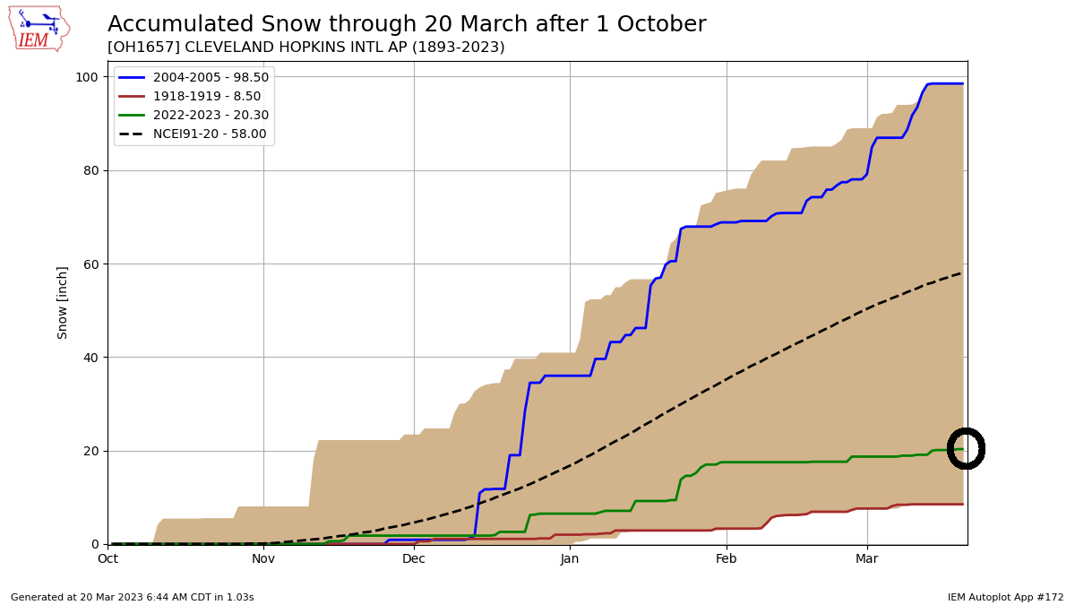

Snowfall as of this writing in Cleveland is barely above 20 inches.  Yet the liquid precipitation (rain and snow combined) is north of 12 inches!


Before we attempt to answer this let's recap the winter storm track. After one of the warmest winters on record here in northern Ohio and across a large portion of the Great Lakes and Ohio valley, storm systems coming out of Texas ended up producing more rain on the southern end of the track with heavy snow staying across the northern states. Total precipitation (rain and snow) was well above normal in areas that saw above normal snowfall vs areas that saw more rain than snow.


Total precipitation from November through December was well below normal. January through mid March total precipitation was well above normal.


So how much snow would all of this precipitation give us if we converted ALL of it to snow?  

Converting liquid precipitation to snow using a (15" of snow to 1" liquid ratio) would give us these numbers (orange) vs actual snowfall (blue).  15 to 1 ratio is arbitrary as wetter snow would closer to 10 to 1 and super-dry snow could be as high as 25 to 1.  I took the middle ground.  The higher the orange line, the more total precipitation thus more potential snow (if converted).


Next we need to find the difference between the actual snowfall (blue above) each winter from the total converted liquid to snowfall (orange) to give us the remaining potential snow.  The larger the difference, the more liquid precipitation (converted to snow) that winter. I plotted each year's difference in the bar graph below.  


The top 10 highlighted below with 2022-23 highlighted for reference.
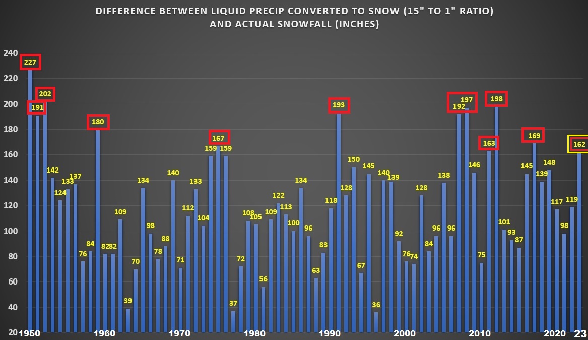

Bottom line is that the winter liquid precipitation (after subtracting the actual snowfall) this winter when converted to potential snow yielded a number just outside the top 10 highest since 1950 (graphic above). This winter had the highest liquid to potential snow since the winter of 2017-18 and a 36% increase comparing this winter to last winter and 65% increase compared to two winters ago. Yet this winter didn't crack the top of the list but its up there. 

1949-50:  227"

1951-52:  202"

2011-12:  198"

2007-08:  197"

1990-91:  193"

2006-07:  192"

1950-51:  191"  

1958-59:  180"

2016-17:  169"

1974-75:  167"

2010-11:  163"

2022-23:  162"

Thursday, April 09, 2015

Heavy Rain and Storms Today

Our first real taste of widespread rain and storms since late last year. Rainfall amounts could exceed an inch over the next 24 hours where heavier downpours develop.


Current LIGHTNING STRIKES HERE


Severe storms are possible. The Storm Prediction Center has places northern Ohio in a SLIGHT RISK with the biggest threat coming from HIGH WINDS.


Remember, the SPC has changed their severe risk categories. Here is a chart comparing the old to the new.

A severe storm does not mean that storm will include tornadoes as many believe. In fact, less than 10 PERCENT or severe storms produce tornadoes.

Current Ohio Valley radar loop

Central Great Lakes sector loop

Tuesday, April 07, 2015

First Taste Of Spring Features Frequent Rains

Stalled front across northern Ohio is the focal point for clusters of rain and a few storms. Notice that these rain clusters move fairly fast with dry breaks in their wake. This will be the general weather outlook through early Friday.


Current OHIO temperatures


Current Ohio Valley radar loop
Central Great Lakes sector loop

Thursday, October 02, 2014

Huge Changes - CURRENT RADAR LOOPS and OHIO TEMPERATURES

CURRENT RADAR LOOPS AND CURRENT OHIO TEMPERATURE, TEMPERATURE FORECAST THROUGH SATURDAY MORNING


Current OHIO temperatures


Current Ohio Valley radar loop
Central Great Lakes sector loop

Temperature forecast for this afternoon...70s...dropping into the 50s...40s by early morning.


Wednesday, October 01, 2014

HUGE changes Friday & Saturday

Welcome to October.

The deeper we go into October, the possibility of more drastic the day-to-day weather changes increases. The next few days are a prime example.

Central Great Lakes sector loop

High temperatures Friday could push into the 70s before the cold front move through.

Friday's Temperatures
Widespread rain and storms Friday afternoon with scattered storms Friday evening for high school football.

Wind gusts could reach 40+ mph along the front late Friday state wide.

 ...then the big drop Saturday across the midwest and Great Lakes.

Saturday's Temperatures
Look how the flood gates open up as the jet stream buckles across the lakes keeping temps in the 50s through early next week.

It won't be long now before I will need to reference my LAKE EFFECT SNOW EVENTS book!


Wednesday, September 10, 2014

Wednesday 9/10 RADAR UPDATES

CURRENT RADAR LOOPS AND CURRENT OHIO TEMPERATURES. Heavy rain approaching.


Current OHIO temperatures


Current Ohio Valley radar loop
Central Great Lakes sector loop


Tuesday, September 09, 2014

Huge Temperature Changes...Severe Weather Possible

It's not all that unusual to see large temperature changes driven by strong cold fronts this time of year. Even though it is technically still summer, the sun isn't as strong as it was in early August. The early pushes of cooler air are becoming stronger and larger in extent.  The polar jet stream is starting to become a more dominating force driving mid latitude systems the US and Canada much faster and with more punch. The front forecast to push through the Great Lakes late Wednesday/early Thursday is a prime example.

HUGE temperature contrast along the front.
Incidentally, last year almost to the day, we had a similar cold front and huge temperature contrast. We went from 96 and 95 to 62 in under 48 hours!

Atmosphere is very buoyant.
 Precipitable water values are well over 2 inches!
 
Jet stream winds are very strong. Right-rear quadrant of the jet streak (diverging air aloft) over the mid-west will enhance the severe storms as they pass over Indiana and western Ohio.
Storm Prediction Center continues to show a slight risk for severe storms into northwestern Ohio for late Wednesday and early Thursday.
At this writing, line of storms should pass through northern Ohio between midnight Thursday and Thursday at 6am.
Temperatures will fall into the upper 50s and lower 60s Saturday.

The cool push of air is very strong and will envelop the northern 2/3rds of the US.


Sunday, August 31, 2014

Labor Day Weekend Weather Radar for Northern Ohio

Happy Labor Day Weekend!

Most of the heavier rain will stay well south today. CHECK OUT THE CURRENT RADAR LOOPS AND CURRENT OHIO TEMPERATURES...


Current OHIO temperatures


Current Ohio Valley radar loop
Central Great Lakes sector loop


Tuesday, June 24, 2014

Heavy Rain Update: Flash Flood Potential VERY HIGH

The ground is saturated from Monday's rain. An additional 1-3" of rain a very good possibility over the next 18 hours. Flash Flooding is the greatest concern. FLASH FLOOD WATCH FOR ALL OF NORTHERN OHIO UNTIL 10PM THIS EVENING. THIS MIGHT BE EXTENDED.

CURRENT RADAR LOOPS AND CURRENT OHIO TEMPERATURES


OHIO TEMPERATURES


OHIO VALLEY RADAR LOOP

Central Great Lakes sector loop

.