Showing posts with label severe storms. Show all posts

Monday, June 19, 2023

Tornado Recap

For the first time since early September last year, northern Ohio saw it's first tornado warnings June 15.  Not the latest on record but close. 

Latest first tornado warning in order (after June 1st):

July 24, 2005

June 24, 1999

June 22, 1990

June 19, 2021

June 15, 2023

June 5, 2016

June 3, 1989

June 1, 1987

Not every tornado warning means there were actual touchdowns.  In most instances (75% of the time approximately) the warning is issued due to doppler radar indicated rotation within the storm.  Last Thursday, not only did we have multiple tornado warnings, we had multiple tornadoes!  Here is the list: (h/t Mackenzie Bart and Dontae Jones for the graphic)


NWS statement here

Red dots indicate the approximate location of each tornado


Here is a nice video of a constructed powerpoint of the entire severe storm event via the Iowa State University - Mesonet Site (IEM Raccoon).  88 slides total. 5 seconds per slide. Well worth it.

Video format from youtube


Wednesday, September 10, 2014

Wednesday 9/10 RADAR UPDATES

CURRENT RADAR LOOPS AND CURRENT OHIO TEMPERATURES. Heavy rain approaching.


Current OHIO temperatures


Current Ohio Valley radar loop
Central Great Lakes sector loop


Tuesday, September 09, 2014

Huge Temperature Changes...Severe Weather Possible

It's not all that unusual to see large temperature changes driven by strong cold fronts this time of year. Even though it is technically still summer, the sun isn't as strong as it was in early August. The early pushes of cooler air are becoming stronger and larger in extent.  The polar jet stream is starting to become a more dominating force driving mid latitude systems the US and Canada much faster and with more punch. The front forecast to push through the Great Lakes late Wednesday/early Thursday is a prime example.

HUGE temperature contrast along the front.
Incidentally, last year almost to the day, we had a similar cold front and huge temperature contrast. We went from 96 and 95 to 62 in under 48 hours!

Atmosphere is very buoyant.
 Precipitable water values are well over 2 inches!
 
Jet stream winds are very strong. Right-rear quadrant of the jet streak (diverging air aloft) over the mid-west will enhance the severe storms as they pass over Indiana and western Ohio.
Storm Prediction Center continues to show a slight risk for severe storms into northwestern Ohio for late Wednesday and early Thursday.
At this writing, line of storms should pass through northern Ohio between midnight Thursday and Thursday at 6am.
Temperatures will fall into the upper 50s and lower 60s Saturday.

The cool push of air is very strong and will envelop the northern 2/3rds of the US.


Tuesday, June 17, 2014

VIDEO: Double Tornadoes in Nebraska

Its a rarity to capture DOUBLE TORNADOES on video.


These tornadoes killed two people in Nebraska (first tornado fatalities in Nebraska since 2004) and leveled a significant portion of the town of Pilger 100 miles northwest of Omaha.

These tornadoes were a part of a fairly large severe storm area Monday.


The Palm Sunday Tornado Outbreak in 1965 featured a double tornado. The Detroit NWS Office has a great discussion on the meteorological setup for that event. The May 3, 1999 event in Oklahoma was a larger outbreak resulting in 74 tornadoes had a double tornado.

Photo: NOAA 1965
The tornado outbreak in 1965 was further east than yesterday's event.

Tornadohistoryproject.com
In most instances when two tornadoes form close to one another, one of the tornadoes becomes the dominant player while one dies away. Yesterday, both tornadoes sustained their intensities creating two separate destructive paths. How strong were these tornadoes? The National Weather Service will survey the damage and make a determination soon.

Tuesday, May 20, 2014

Never Trust A Warm Front--Heavy Rain Again!

"Never Trust A Warm Front"!

These words of Dick Goddard and Andre Bernier have also been echoed by myself over the years after forecasting many heavy rain and nighttime severe weather events in northern Ohio, West Virginia and St. Louis going back more than 20 years.

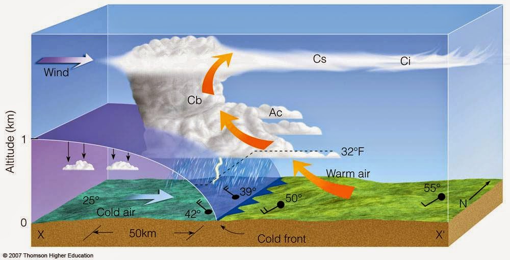
Why are warm fronts so tricky? The dynamics of a warm front are completely different than a cold front. The cross section of each tell the story on how the air is stacked above each front. A more detailed technical discussion is located on this site with a nice powerpoint download.

Cold Front Cross Section
Warm Front Cross Section
Clusters of "blob-like" storms tend to develop along warm fronts. These clusters start vie for position and dominance as they move into areas more conducive for sustainability. One cluster robs another of energy/moisture in order to sustain itself while other might shrink.  Yet several clusters might merge together to form one super cluster as was the case on Monday, May 12th. Radar loop is over approx 40 minutes from 8PM to 8:40PM over northern Ohio.


The combination of a moisture-laden atmosphere, rapidly rising and divergent (separating air) at the top of the storms along with hyper-local changes as the storms evolve over a small area make these clusters very difficult to predict more than a few hours in advance in many instances. Their non-linear nature makes it very difficult to determine an accurate track and duration.  They can become especially powerful during the overnight/predawn hours. The high resolution NAM below (future radar) shows several clusters overnight Tuesday into Wednesday more than 24 hours in advance. Their movement is usually west to east or northwest to southeast along the warm frontal boundary.


Compare that to what a "typical" line of storms looks like along a powerful cold front.


So watch the radar below tonight and early Wednesday for the "cluster-type" setup. These clusters can accelerate and morph into hail producing, high wind storms easily reach severe limits.

I GUARANTEE THAT SOME LOCATIONS WILL RECEIVE MORE THAN 1" OF RAINFALL ON WEDNESDAY!


Central Great Lakes sector loop