Showing posts with label radar. Show all posts

Monday, May 25, 2015

Short Range Computer Projection vs Actual Radar

Its Memorial Day here at the station. I remember my dad, grandfather, uncle, brother-in-law who served in our Armed Forces over the generations.

I've been watching a few showers popping up on radar.  Nothing heavy, nothing widespread.  One helpful tool we use in determining where and when precipitation develops is the newly operational HRRR model (short for High Resolution Rapid Refresh).  In essence, this model assimilates 3 km radar data into it calculation each hour.  So rather than wait a full 6 hours until the next set of model outputs, the HRRR runs a NEW output every 60 minutes taking into account the ew radar information.

This morning, I ran a little experiment to see how accurate the HRRR was in determining the light showers it was showing for 9AM.  The NWS Cleveland radar was down for repairs so this was a perfect opportunity to see how this would affect the output.

Here is the HRRR Output each hour starting with the 5z (1am) run and concluding with the 11z (7am) run.  So the 5z run is 8 hours from 9am.  The 11z run is 2 hours from 9am.  So each successive model run brings us closer to the 9am target time. 

A light shower west of Cleveland...


By the 8z run, the HRRR started to shift the light shower further west into the main cluster of rain along the Ohio/Indiana border.  By 11z, it had merged with the western rain area.

Here is what the actual radar looked like at 9AM using the TDWR radar in Grafton since the NWS radar was still down as of this writing.  Hardly any precipitation!


Thinking outloud...

*  The HRRR overestimated the development 
*  Unknown whether Cleveland radar downtime had an affect
*  Unknown whether or not TDWR radar data from the FAA is incorporated into HRRR model.


Tuesday, October 07, 2014

Current Radar Loops and Ohio Temperatures


Current OHIO temperatures


Current Ohio Valley radar loop
Central Great Lakes sector loop


Thursday, October 02, 2014

Huge Changes - CURRENT RADAR LOOPS and OHIO TEMPERATURES

CURRENT RADAR LOOPS AND CURRENT OHIO TEMPERATURE, TEMPERATURE FORECAST THROUGH SATURDAY MORNING


Current OHIO temperatures


Current Ohio Valley radar loop
Central Great Lakes sector loop

Temperature forecast for this afternoon...70s...dropping into the 50s...40s by early morning.


Tuesday, May 20, 2014

Never Trust A Warm Front--Heavy Rain Again!

"Never Trust A Warm Front"!

These words of Dick Goddard and Andre Bernier have also been echoed by myself over the years after forecasting many heavy rain and nighttime severe weather events in northern Ohio, West Virginia and St. Louis going back more than 20 years.

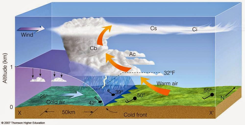
Why are warm fronts so tricky? The dynamics of a warm front are completely different than a cold front. The cross section of each tell the story on how the air is stacked above each front. A more detailed technical discussion is located on this site with a nice powerpoint download.

Cold Front Cross Section
Warm Front Cross Section
Clusters of "blob-like" storms tend to develop along warm fronts. These clusters start vie for position and dominance as they move into areas more conducive for sustainability. One cluster robs another of energy/moisture in order to sustain itself while other might shrink.  Yet several clusters might merge together to form one super cluster as was the case on Monday, May 12th. Radar loop is over approx 40 minutes from 8PM to 8:40PM over northern Ohio.


The combination of a moisture-laden atmosphere, rapidly rising and divergent (separating air) at the top of the storms along with hyper-local changes as the storms evolve over a small area make these clusters very difficult to predict more than a few hours in advance in many instances. Their non-linear nature makes it very difficult to determine an accurate track and duration.  They can become especially powerful during the overnight/predawn hours. The high resolution NAM below (future radar) shows several clusters overnight Tuesday into Wednesday more than 24 hours in advance. Their movement is usually west to east or northwest to southeast along the warm frontal boundary.


Compare that to what a "typical" line of storms looks like along a powerful cold front.


So watch the radar below tonight and early Wednesday for the "cluster-type" setup. These clusters can accelerate and morph into hail producing, high wind storms easily reach severe limits.

I GUARANTEE THAT SOME LOCATIONS WILL RECEIVE MORE THAN 1" OF RAINFALL ON WEDNESDAY!


Central Great Lakes sector loop

Saturday, May 17, 2014

Weekend Northern Ohio Radar Loops - Temperatures

CHECK OUT THE CURRENT RADAR LOOPS AND CURRENT OHIO TEMPERATURES


Current OHIO temperatures


Current Ohio Valley radar loop
Central Great Lakes sector loop

.


Thursday, May 15, 2014

Radar Loops, Heavy Rainfall Forecast

More steady rainfall today. CHECK OUT THE CURRENT RADAR LOOPS AND CURRENT OHIO TEMPERATURES...RAINFALL FORECAST AT THE BOTTOM


Current OHIO temperatures


Current Ohio Valley radar loop
Central Great Lakes sector loop


Projected rainfall amounts are significant. Flash Flood Watch will need to be issued later today by the NWS.